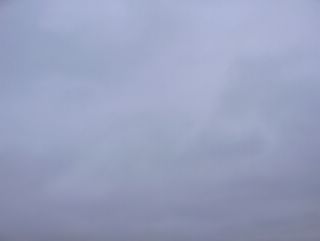
Nyt eteläinen Suomi kuului kahden eri ilmamassan rajavyöhykkeeseen, missä lännen laajasta matalapaineesta ulottui paikallaan pysynyt kieleke itään. Sen eteläpuolelle kevät oli jo tullut, mutta sen pohjoispuolella oli vielä kylmää ja talvista pakkasilmaa. Kuvauspaikalla tilanne näkyi vahvana ja aukkoamattomana pilvikerroksena, jossa alimmaisena oli runsaasti sumupilviä ja niiden yläpuolella vaihtelevasti mm. sade- ja kuuropilviä. Sumuakin esiintyi, koska tuulet olivat ajoittain heikkoja ja kylmän alustan päälle (luminen maa) virtasi aikaisempaa lämpimämpää ja kosteaa ilmaa (vuorokauden keskilämpötila oli vain asteen pakkasella ja jo aamulla oli suojaa). Koko taivas näytti tässä sumuisessa tilanteessa kuvan tapaan tasaisen harmaalta, koska sumu sumensi kaikkien pilvien muodot pois näkyvistä. Kuva on otettu Espoon Tapiolassa kaakkoistaivaalle. Säätilanne: valitse 28.3.2006; Wetter3 A. Wetter3 B.
Now southern Finland was in the borderline of two different air masses, where a stationary strip from the wide low pressure in the west reached to the east. Southside of it the spring had allready started, but northside of it there was yet cold and wintry frosty air. In the photoshooting scene the situation showed as a thick and unbreakable cloud cover, where the lowest were big amount of stratus clouds and on the upperside of them for example nimbus and cumulonimbus clouds in variable ways. Fog also appeared, because the winds were occasionally weak and moist and warmer air than before (the daily mean temperature was now only one degree freezing and it was thaw allready in the morning) flowed over the cold surface (snowy ground). The whole sky looked in this foggy situation evenly grey like in the picture, because the fog blurred the shapes away from all clouds. The photo is taken in the district of Tapiola in Espoo towards southeastern sky. Weather condition: choose 28.3.2006; Wetter3 A. Wetter3 B.Helsingin Puistolan säätilasto maaliskuussa 2006 - Weather chart of Puistola, Helsinki in March 2006.Flickr 1 Flickr 2 
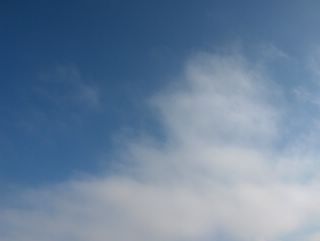
Tämä kuva oli otettu puolisen tuntia myöhemmin samana päivänä Espoon Tapiolassa kuin edellinen kuva, mutta nyt kohti luoteistaivasta. Em. lämpimän rintaman suunta paljastui hyvin myös tästä kuvasta, sillä untuva-, harso- ja tässä myös verhopilvien kilpimäiset ja nauhamaiset muodot olivat asettuneet rintaman myötäisesti pohjois-eteläsuunnassa. Niinpä kuvaussuunta näyttää nuo nauhamaiset koko taivaan yli ulottuneet muodot näin. Tämä hyvin heikko rintama (joissakin sääkartoissa sitä ei edes merkitty) ei tuonut sadetta eikä ilmakaan vielä lämmennyt. Tuuli oli tässä vaiheessa heikkoa. Säätilanne: valitse 26.3.2006; Wetter3 A. Wetter3 B.
This picture was taken about half an hour later in the same day as the previous picture in the district of Tapiola in Espoo, but now towards northwestern sky. The direction of the mentioned warm front was revealed finely also from this photo, because the shield- and stripelike shapes of the cirrus, cirrostratus and here also altostratus clouds were lined according to the front in the direction of north and south. So the shooting direction of the photo shows these over the whole sky reaching stripelike forms in this way. This very weak front (on some weather maps it wasn't even marked) didn't brought precipitation and the air didn' t got warmer either. Winds were weak at this stage. Weather condition: choose 26.3.2006; Wetter3 A. Wetter3 B.Helsingin Puistolan säätilasto maaliskuussa 2006 - Weather chart of Puistola, Helsinki in March 2006.Flickr 1 Flickr 2

Tässä vaiheessa Suomi oli kapean korkeapaineen selänteen alueella, missä kuvauspaikkakin kuului vielä kylmän talvisen ilmamassan alueeseen; yölämpötila oli -10,8 ja päivälämpötila +1,3 astetta. Lännestä käsin vaikutti kuitenkin heikko lämmin rintama ja siihen liittyen taivaalla oli tässä tilanteessa untuva- ja harsopilviä auringon paistaessa heikosti niiden läpi. Rintama oli osa idän matalapaineen länteen ulottuvaa kylmää rintamaa. Tässä kuvassa nähdään, kuinka em. pilvilajit olivat muuttuneet osaksi palleropilvien kaltaisiksi; aaltomaiset osat kuvan yläreunassa. Kuva on otettu Espoon Tapiolassa itätaivaalle. Säätilanne: valitse 26.3.2006; Wetter3 A. Wetter3 B.
At this stage Finland was in the narrow ridge of high pressure, where the photoshooting scene was also yet in the cold and wintry air mass; the night temperature was -10,8 C and the daytime temperature was +1,3 C. However a weak warm front affected from the west and due to that there were cirrus and cirrostratus clouds in the sky in this situation when the sun shined weakly through them. The front was a part of a cold front that reached to the west from the eastern low pressure. In this picture we see, how these clouds had been changed partly into cirrocumulus type of clouds; the undulating parts on the upper half of the photo. The picture is taken in the district of Tapiola in Espoo towards eastern sky. Weather condition: choose Base Time 26.3.2005; Wetter3 A. Wetter3 B.Helsingin Puistolan säätilasto maaliskuussa 2006 - Weather chart of Puistola, Helsinki in March 2006.Flickr 1 Flickr 2

Tänä päivänä esiintyi myös kumpupilviä, mutta kylmässä ja voimakkaassa pohjoistuulessa lähellä itäistä matalapainetta osa kumpupilvistä kehittyi kuuropilviksi asti iltapäivällä. Merituulta ei ollut tässä tilanteessa. Kuvassa oli yhden tällaisen kuuropilven yläosa. Sade tuli kokonaan lumena tai lumirakeina; päivän ylin lämpötila oli -2,1 astetta. Tällaiset kuuropilvet olivat kuitenkin lähestyvän kevään merkki, sillä em. termiikki vaikutti jo kuuropilvien korkeuteen ja esiintymiseen niitä voimistavasti. Kuvauksen myöhäinen iltapäivän ajankohta paljasti myös valon lisääntyneen. Näin kylmässä ilmamassassa ko. pilvet olivat silti vielä varsin matalia eivätkä ollenkaan vielä tornimaisia ja kumpuosiltaan kukkakaalimaisia, kuten kesällä. Niinpä nämä kuuropilvet muistuttivat lähinnä vain hieman pullistuneita kumpukerrospilviä. Kuva on otettu Espoon Tapiolassa etelätaivaalle. Säätilanne: valitse 20.3.2006; Wetter3 A. Wetter3 B.
During this day the cumulus clouds appeared as well, but in the cold and strong northerly wind near the eastern low pressure part of the cumulus clouds evolved into cumulonimbus clouds in the afternoon. There was no sea breeze in this situation. In the picture there was a top of the one this kind of cumulonimbus or showercloud. The precipitation came entirely in the form of snow or snowy hale; the maximum temperature was -2,1 C. However these kinds of cumulonimbus clouds were a sign of nearing spring, because the thermal column of the air affected allready to the height and to the appearance of the cumulonimbus clouds as making them stronger. The late afternoon moment of the photoshoot revealed, that the light had also increased. In this kind of cold air mass these clouds were rather low though and not yet towerlike and cauliflowery in the cumulus parts at all like in summer. So these showerclouds resembled mainly just a little flatulent stratocumulus clouds. The picture is taken in the district of Tapiola in Espoo towards southern sky. Weather condition: choose 20.3.2006; Wetter3 A. Wetter3 B.Helsingin Puistolan säätilasto maaliskuussa 2006 - Weather chart of Puistola, Helsinki in March 2006.Flickr 1 Flickr 2
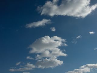
Matalapaine oli tämän kuvan tilanteessa voimistunut Suomen itäpuolelle luoteesta ja pohjoistuuli oli voimistumassa. Sää oli tilapäisesti melkein selkeää kahden eri kuurosadealueen välissä, jotka liittyivät kylmän ilman tuloon paikalle. Vain vähän kumpupilviä seilasi taivaalla. Kumpupilvien esiintyminen tähän aikaan vuodesta tällaisessa kylmässä polaarisessa ilmamassassa oli kevään merkki, sillä voimistunut auringonsäteily mahdollisti aikaisempaa voimakkaammat ilman nousuvirtaukset eli termiikin, joka on kumpupilvien edellytys. Kevään merkkinä heikko merituuli piti nämä pilvet pois Suomenlahden yltä, mutta voimistuva pohjoistuuli kumosi pian sen vaikutuksen. Kuva on otettu Espoon Tapiolassa kaakkoistaivaalle. Säätilanne: valitse 19.3.2006; Wetter3 A. Wetter3 B.
In the situation of this picture a low pressure had been strengthened from the northwest to the eastern side of Finland and northerly winds were picking up. The weather was temporarily allmost clear between two showery precipitation areas, which were associated with the cold air arriving the scene. Only a little amount of cumulus clouds floated in the sky. The appearance of the cumulus clouds in this time of the year during this kind of cold and polaric air mass was a sign of spring, because strengthened radiation of the sun caused stronger upward air flows than before. In other words thermal columns of the air, which is the precondition of the cumulus clouds. As a sign of spring a weak sea breeze kept these clouds away over The Gulf Of Finland, but the picking up northerly wind overruled the effect of it soon. The photo is taken in the district of Tapiola in Espoo towards southeastern sky. Weather condition: choose 19.3.2006; Wetter3 A. Wetter3 B.Helsingin Puistolan säätilasto maaliskuussa 2006 - Weather chart of Puistola, Helsinki in March 2006.Flickr 1 Flickr 2
Edellisiin sumupilvisiin päiviin verrattuna ko. päivänä sumupilvien haihtuminen oli alkanut aikaisemmin kuin ennen. Lähestyvän kevään merkkejä oli juuri tällainen auringon vaikutus, joka kumosi muutoin tällaisessa heikkotuulisessa korkeapaineessa viipyvien sumupilvien esiintymisen. Mitä lämpimämpi vuodenaika, niin sitä vähemmän sumupilviä yleensä esiintyy. Niinpä kesällä sumupilviä esiintyy lähinnä vain voimakkaiden sadealueiden (sisältää myös kuuro- ja ukkospilvet) yhteydessä ja yöllä - varhain aamulla. Talvella sumupilvet ovat tyypillisiä ympäri vuorokauden monissa säätilanteissa. Lämpenevässä säätilanteessa keväällä (lumen sulettua) ja alkukesällä sumupilviä (ja sumua) esiintyy rannikolla enemmän kuin sisämaassa (kylmin alusta on rannikolla; meri). Syksyllä ja talvella samassa tilanteessa sumupilviä (ja sumua) esiintyy eniten sisämaassa (kylmin alusta on sisämaassa). Kuva on otettu Espoon Tapiolassa itätaivaalle. Säätilanne: valitse 15.3.2006; Wetter3 A. Wetter3 B.
As compared to the stratus cloud filled previous days the evaporation of the stratus clouds had been started earlier than before in this day. The sign of the nearing spring was exactly this kind of effect of the sun, which overruled the stratus clouds from appearing, which otherwise linger during this kind of slightly windy high pressure. The warmer the season is the less stratus clouds will usually appear. Therefore in the summer stratus clouds only appear mainly associated with strong precipitation areas (including shower and thunder clouds) and at night - in early morning. In winter the stratus clouds are typical around the clock in many weather situations. During warm up of the weather in spring (after the snow melt) and early summer stratus clouds (and fog) are appearing more by the coast than in inland (the coldest surface is by the coast; the sea). In autumn and winter in the same situation the stratus clouds (and fog) are appearing more in inland areas than by the coast (the coldest surface is in inland areas). The photo is taken in the district of Tapiola in Espoo towards eastern sky. Weather condition: choose 15.3.2006; Wetter3 A. Wetter3 B.Helsingin Puistolan säätilasto maaliskuussa 2006 - Weather chart of Puistola, Helsinki in March 2006.Flickr 1 Flickr 2
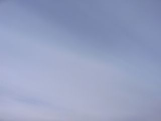
Edelliseen kuvaan verrattuna tässä oli muutoin hyvin samanlaisia sumupilviä, mutta niiden värisävy oli hieman erilainen. Tämä johtui näiden eri päivien pilvikerrosten yläpuolella olleista erilaisista pilvitilanteista, missä esim. untuvapilviä liikkui vaihtelevasti kuvauspaikan yllä. Niinpä myös auringon valon sävy oli vaihtelevaa. Kuva on otettu Espoon Tapiolassa länsitaivaalle. Säätilanne: valitse 14.3.2006; Wetter3 A. Wetter3 B.
As compared to the previous picture here were otherwise same kinds of stratus clouds, but the colour of them were slightly different. This was due to the different cloud situations above these cloud layers during these different days, where for example cirrus clouds were moving over the scene variably. So the tone of the sunlight was also variable. The picture is taken in the district of Tapiola in Espoo towards western sky. Weather condition: choose 14.3.2006; Wetter3 A. Wetter3 B.Helsingin Puistolan säätilasto maaliskuussa 2006 - Weather chart of Puistola, Helsinki in March 2006.Flickr 1 Flickr 2

Tässä ja ylemmässä kuvassa oli sumupilvikerros, joka johtui korkeapaineen vahvistumisen myötä heikkona virinneestä lauhemmasta kaakkoistuulesta. Heikossa tuulessa sumupilvillä oli taipumus säilyä pitkään tässä vaiheessa, kun leudompaa ilmaa oli alkanut virrata kovien pakkasten jäljiltä kylmän alustan päälle (luminen maa ja jäätynyt Suomenlahti). Ajoittain taivas oli kuitenkin osittain selkeä myös näinä päivinä mm. voimistuneen auringonsäteilyn ansiosta. Tämä kuva on kuvattu Espoon Tapiolassa kaakkoistaivaalle. Säätilanne: valitse 13.3.2006; Wetter3 A. Wetter3 B.
In this and the picture above there was a layer of stratus clouds, which was due to the strengthening of a high pressure and a milder southeasterly wind picked up weakly. In the slight wind the stratus clouds had a liability to linger on for a long time at this stage, when milder air had been started to flow over the cold surface (snowy ground and frozen The Gulf Of Finland) after the severe frosts. However the sky was occasionally partly clear also during these days for example due to the strengthened radiation of the sun. This photo is taken in the district of Tapiola in Espoo towards southeastern sky. Weather condition: choose 13.3.2006; Wetter3 A. Wetter3 B.Helsingin Puistolan säätilasto maaliskuussa 2006 - Weather chart of Puistola, Helsinki in March 2006.Flickr 1 Flickr 2

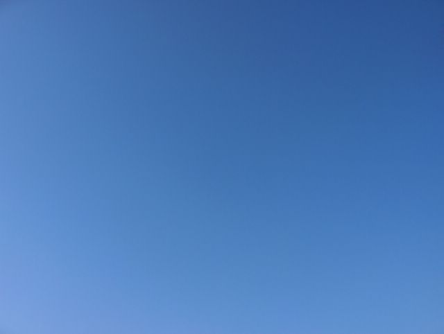
Hyvin talvinen sää jatkui edelleen pakkasilman jähmetyttyä paikalleen ja korkeapaineen selänteen estettyä lännen matalapaineiden vaikutuksen, mutta edelliseen päivään verrattuna nyt oli täysin selkeää. Tilanteen hyvin kuiva pakkasilmamassa loi olosuhteet taivaan erittäin vahvalle sinisyydelle pilvien kaikottua, koska ilmassa oli hyvin vähän samentavaa vesihöyryä. Pilvien poistuminen ja samalla yhä koko päivän hyvin tyynenä jatkunut tuuli tiesivät lämpötilan vuorokausivaihtelun suurentumista; ylin lämpötila oli -6,9 ja alin -19,3 astetta. Kuva on otettu Espoon Tapiolassa pohjoistaivaalle. Säätilanne: valitse 8.3.2006; Wetter3 A. Wetter3 B.
Very wintry weather continued further as the frosty air was stuck in place and a ridge of high pressure was blocking the influence of western low pressures, but as compared to the previous day it was now completely clear. The very dry air mass in the situation created circumstances for the strong blue colour of the sky after the clouds disappeared, because the air contained very little amount of blurring water vapour. The disappearing of the clouds and continued very still winds all day meant enlarging of the cycle of night and daytime temperature; the maximum temperature was -6,9 C and the minimum temperature -19,3 C. The photo is taken in the district of Tapiola in Espoo towards northern sky. Weather condition: choose 8.3.2006; Wetter3 A. Wetter3 B.Helsingin Puistolan säätilasto maaliskuussa 2006 - Weather chart of Puistola, Helsinki in March 2006.Flickr 1 Flickr 2
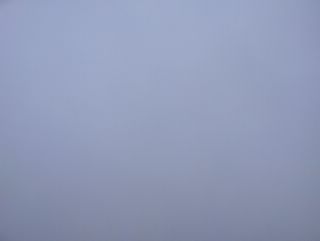
Edelliseen kuvaan verrattuna tässä heikosta lumisateesta ja sumupilvimäisistä sadepilvistä muodostunut kerros oli hyvin vähäinen. Aurinko paistoi melko kirkkaasti, mutta taivas ei ollut kovin sininen. Ilmamassa oli edelleen ajankohtaan nähden erittäin kylmää ja kuivaa. Tuuli oli koko päivän hyvin heikkoa, koska Suomen yllä oli vain epämääräinen heikko matalapaine arktisessa ilmamassassa. Alin lämpötila oli ko. yönä -16,2 astetta ja päivälämpötila -6,6 astetta. Tyypilliseen maaliskuun tapaan lämpötilan vuorokausivaihtelu oli jo suurta kevättä enteillen. Kuva on otettu Espoon Tapiolassa kaakkoistaivaalle. Säätilanne: valitse 7.3.2006; Wetter3 A. Wetter3 B.
As compared to the previous picture here the layer of weak snowing and stratus cloudlike nimbostratus clouds was very slight. The sun was shining rather brightly, but the sky wasn't much blue. The air mass was further very cold for the time of the year and dry. The wind was very weak all day, because only a indefinite and weak low pressure was over Finland in the arctic air mass. The minimum temperature at this night was -16,2 C and the daytime temperature was -6,6 C. In the typical way of March the cycle of night and daytime temperature was large foreseeing the spring. The picture is taken in the district of Tapiola in Espoo towards southeastern sky. Weather condition: choose 7.3.2006; Wetter3 A. Wetter3 B.Helsingin Puistolan säätilasto maaliskuussa 2006 - Weather chart of Puistola, Helsinki in March 2006.Flickr 1 Flickr 2
Matalapaineiden vyöhyke oli järjestymässä Suomen eteläpuolelle ja samalla idästä alkoi ulottua korkeapaineen selänne Pohjois-Suomeen. Siitä johtuen kaakkoistuuli oli kuvauspaikalla kohtalaista ja taivaalla oli ohut kerros sadepilviä, jotka muistuttivat sumupilviä. Aurinko kuulsi vähän tämän kerroksen läpi ja lunta satoi ajoittain. Kuvan tilanteessa lumihiutaleet olivat kuitenkin niin pieniä ja jyväsmäisiä, että yksittäiset hiutaleet eivät näkyneet kirkastakaan taivasta vasten. Sateesta johtuen taivas oli silti tasaisesti sumentunut. Kaikki tämä oli tyypillistä tilanteen pakkasilmamassalle; ylin lämpötila oli -6,9 astetta. Kuva on otettu Espoon Tapiolassa kaakkoistaivaalle. Säätilanne: valitse 1.3.2006; Wetter3 A. Wetter3 B.
Line of low pressures were assembling southside of Finland and at the same time a ridge of high pressure started to reach northern Finland. Due to that southeasterly winds were moderate at the photoshooting scene and in the sky were thin layer of nimbostratus clouds, which resembled stratus clouds. The sun glowed a bit through this layer and it snowed occasionally. However in the situation of the photo the snowflakes were so small and grainlike, that individual snowflakes didn't appear against the bright sky. The precipitation made the sky evenly blur though. All this was typical of the frosty air mass in the situation; the maximum temperature was -6,9 C. The picture is taken in the district of Tapiola in Espoo towards southeastern sky. Weather condition: choose 1.3.2006; Wetter3 A. Wetter3 B.
Helsingin Puistolan säätilasto maaliskuussa 2006 - Weather chart of Puistola, Helsinki in March 2006.Flickr 1 Flickr 2