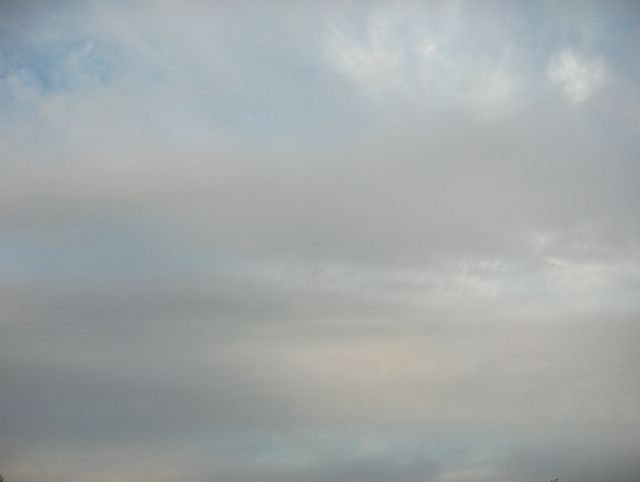
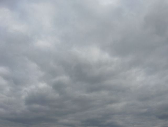
Etelä-Suomen ylle oli kuvan tilanteeseen mennessä jo edellisenä päivänä tullut pieni matalapaine lounaasta. Se toi mukanaan helteistä ilmamassaa välittömästi Suomen etelä- ja kaakkoispuolelle. Lähimmillään ko. ilmamassa oli edellisenä päivänä ja yöllä. Tällöin ilmamassan pohjoisrajalla eteläisessä Suomessa oli rintamavyöhyke sateineen. Kyseessä olleen lämpimän rintaman eteläpuolella ollut helle jäi tulematta, koska matalapaineen ympäri kiertynyt viileämpi ilmamassa työnsi helleilmaa syrjään lännestä ja Etelä-Suomen yllä ollut rintama muuttui sen myötä okluusiorintamaksi. Kuvan tilanteessa okluusiorintama oli jo tämän paikan (Tapiola, Espoo) pohjoispuolella, mutta vielä vallitsi matalapaineen keskusalueen tyyni tilanne, jossa ilmamassa oli kosteaa (ilmassa oli utua ja paikoin sumuakin) ja melkein saapuneen helleilmamassan takia vielä melko lämmintäkin; yön alin lukema oli +12,9 astetta. Aamun jälkeen alkoi kuitenkin vaikuttaa kuivempi ja viileämpi länsituuli, jonka takia pilvien vähenemisestä huolimatta iltapäivän ylin lämpötila oli vain +18,4 astetta. Kuvassa nähdään sumupilviä kuvattuna kohti etelätaivasta. Sumupilvet ovat kesälläkin hyvin samankaltaisia kuin talvella, mutta erona talveen oli esim. tässä tilanteessa sumupilvien yläpuolella olleet pilvet. Kumpukerros- ja aluksi sade- ja kuuropilvetkin olivat lämpimän ilmamassan takia vaihtelevasti konvektiivisia eli kokkareisempia, värikkäämpiä ja paikoin tummempia kuin talvella. Tällöin niiden olemukset vaikuttivat myös sumupilvien näkymiseen; kuten kuvassa nähdään, niin ylemmät pilvet toivat sumupilviin talvea voimakkaammin muotoja ja tummuuseroja esille tilanteen udusta ja heikosta sumustakin huolimatta. Iltapäivällä vallitsivat lähinnä kumpukerros- ja kumpupilvet, joiden konvektiivisuus oli aamua paljon heikompaa. Säätilanne: valitse 28.6.2006; Wetter3 A. Wetter3 B.Until the situation of the photo there had been arrived a low pressure from the southwest over southern Finland allready during the previous day. That brought hot air mass immediately to the southern and southeastern side of Finland. This air mass was the closest during the previous day and at night. At that time in the northern edge of the air mass there was a frontal zone over southern Finland with its rain. The hot air in the southern side of the warm front in question didn't arrive, because a cooler air circulated around the low pressure pushed the hot air aside from the west onwards and the front over southern Finland became an occluded front due to that. In the situation of the photo the occluded front was allready in northern side of this place (Tapiola, Espoo, Finland), but there prevailed yet a calm condition of the low pressure's center area, where the air mass was humid (there was haze and locally also fog in the air) and due to the allmost arrived hot air rather warm as well; the lowest reading of the night was +12,9 C. However after the morning there started to affect a drier and cooler westerly wind, which caused the maximum temperature of the afternoon to be only +18,4 C despite a decreasing of the clouds. In the picture we see stratus clouds photographed towards southern sky. The stratus clouds are very similar also in summer as in winter, but as a difference compared to winter for example in this situation there were clouds above the stratus clouds. Stratocumulus and at first also nimbostratus and cumulonimbus clouds were variably convective due to the warm air mass and they were in other words more lumpy, colourfull and locally darker than in winter. Therefore their appearances affected also to the appearing of the stratus clouds; as we see in the picture the upper clouds brought shapes and grades of darkness more strongly to the stratus clouds than in winter despite haze and slight fog as well in the situation. In the afternoon there prevailed mainly stratocumulus and cumulus clouds, which convectiveness was much lesser than in the morning. Weather condition: choose 28.6.2006; Wetter3 A. Wetter3 B.Helsingin Puistolan säätilasto kesäkuussa 2006 - Weather chart of Puistola, Helsinki in June 2006.
Flickr 1 Flickr 2Tehoisa lämpösumma - The Effective Temperature Sum: 500,7 
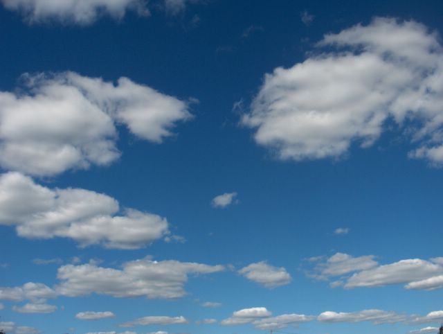
 Suomen eteläpuolella oli tässä vaiheessa heikkenevä pieni korkeapaine, joka muodostui pian edellisen tilanteen rintaman ylityksen jälkeen. Ilmamassa pysyi kuitenkin koko ajan tähän asti tyypillisen kesäisenä eikä helteitä ollut odotettavissa. Samana aikana tuulet olivat heikkoja ja enimmäkseen lännestä. Päivän ylin lämpötila oli ko. päivänä +22,5 ja alin +9,9 astetta. Kuva tilanteessa Lapin tienoille muodostuneen pienen matalapaineen kylmä rintama oli juuri ylittänyt kuvauspaikan Espoon Tapiolan luoteesta kaakkoon. Ko. rintaman untuvapilvivyöhyke oli edelleen etelätaivaalla näkyvissä. Ko. rintama oli muuttumassa lämpimäksi rintamaksi lounaasta lähestyneen matalapaineen takia ja illalla pilvisyys lisääntyi uudestaan lämpimälle rintamalle tyypillisesti; untuvapilvien jälkeen saapuivat harso- ja verhopilvet. Tämän kuvan suunta oli koillistaivaalle, jossa olivat tyypilliset kylmän rintaman jälkeiset sisämaan kumpupilvet ja voimakkaan sininen taivas. Kuvassa nähdään hyvin näiden pilvien esiintymisen raja, koska merituulen takia tämä pilvilaji ei voinut esiintyä meren yllä. Nyt nämä kumpupilvet olivat hieman pulleampia kuin iltapäivän tilanteessa 15. tätä kuuta. Se johtui tämän päivän ilmamassan etenkin korkeammasta lämpötilasta; termiikki / konvektio oli voimakkaampaa. Muutoin tilanne muistutti paljon ko. aikaisemman päivän tilannetta. Säätilanne: valitse 26.6.2006; Wetter3 A. Wetter3 B.At this stage in the southern side of Finland there was a weakening high pressure, which formed soon after the previous situation's crossing of the front. However the air mass remained all the time typically summery up to this point and there wasn't heatwave in the forecast. During the same time winds were weak and mostly from the west. The maximum temperature of the day was +22,5 C and the minimum +9,9 C. In the situation of the photo a cold front of a low pressure formed around Lapland had just been crossed the photoshooting scene the district of Tapiola in Espoo from the northwest to the southeast. The cirrus cloud zone of the front was further appearing in the southern sky. The mentioned front was changing into warm front due to a low pressure approaching from the southwest and in the evening the cloudyness increased again in the typical way of a warm front; after the cirrus clouds there arrived cirrostratus and altostratus clouds. The direction of this photo was towards northeastern sky, where there were cumulus clouds of the inland and the strongly blue sky typical after the cold front. In the picture we see finely the appearing boundary of these clouds, because due to the sea breeze this cloud type wasn't able to appear over the sea. Now these cumulus clouds were a little fatter as compared to the afternoon situation in the 15th day of this month. This was resulted especially by the higher temperature of this day's air mass; the thermal / convection was stronger. Otherwise the situation resembled a lot the situation of that earlier day. Weather condition: choose 26.6.2006; Wetter3 A. Wetter3 B.Helsingin Puistolan säätilasto kesäkuussa 2006 - Weather chart of Puistola, Helsinki in June 2006.
Flickr 1 Flickr 2Tehoisa lämpösumma - The Effective Temperature Sum: 479,4
 Edellisenä päivänä Etelä-Suomen yllä oli koko päivän Alpeille asti ulottuva rintamasysteemi, jossa esiintyi vaihtelevasti kuurottaisia sateita lounaasta käsin. Edellisenä iltana Baltiassa kehittyi jopa voimakkaita ukkosia, mutta niistä vain osa pääsi heikenneinä Suomenlahden yli ja kuvauspaikalla satoi yöllä kuurottaisesti ilman ukkosta. Tämä kuva on otettu Helsingissä Kalliossa ylös keskelle taivasta. Tämän päivän aikana ko. rintama siirtyi vähitellen itään ja sen myötä viileämpi länsituuli alkoi vaikuttaa. Aluksi tuulet olivat jopa tyyniä, mutta illalla länsituuli oli ajoittain kohtalaista. Kuvan vaiheessa rintaman pilvivyöhyke oli pohjois - eteläsuuntaisena vyönä jo itäisellä taivaanrannalla, mutta kuvassa nähdään vielä sen jäljessä tyypillisesti esiintynyttä untuvapilvinauhaa myös rintaman myötäisenä. Edellisenä päivänä oli helteisen ilmamassan utua ja rintamapilvisyys oli vaihtelevasti etenkin hahtuva-, kumpukerros- ja kuuropilviä konvektiivisina. Yön sateen aikana kuuropilvet muuttuivat muistuttamaan vanhetessaan ja levitessään sadepilviä ja sateen jälkipuolella aamulla oli myös sumupilviä. Aamun jälkeen ilma kirkastui (utu kaikkosi) edellisestä päivästä ja hitaasti ylittävässä pilvivyöhykkeessä olivat lähinnä hahtuva- ja kumpukerrospilvet vähemmän konvektiivisina kuin edellisenä päivänä. Viimeisenä ennen selkenemistä oli harso-, verho- ja untuvapilviä rintaman suuntaisina raitoina. Selkenemisen raja oli terävä ja iltaruskon värejä ei ehtinyt ilmaantumaan kunnolla myöhään paistaneen auringon takia; kesäpäivänseisaus oli 21. päivänä. Sää viileni rintaman jälkeen; päivän ylin lukema oli vain +19,7 astetta. Koska ko. päivän yönä ilmamassa ei ollut vielä vaihtunut kunnolla, niin yöllä oli melkein yhtä lämmintä ja tämän päivän alin lukema +12,9 astetta saavutettiin vasta ko. kuvaushetken jälkeen keskiyöllä ennen päivän vaihtumista. Tämä päivä oli Juhannusaatto. Säätilanne: valitse 23.6.2006; Wetter3 A. Wetter3 B.In the previous day there was a frontal system all day over southern Finland reaching as far as The Alps and in it there appeared variable showery rains from the southwest. During the previous evening there formed even severe thunder in Baltic, but only part of them had a chance to cross The Gulf Of Finland in weakened forms and in the photoshooting scene showery rain came at night without thunder. This photo is taken in the district of Kallio in Helsinki up towards the zenith of the sky. During this day the front moved slowly to the east and along with that a cooler westerly wind started to affect. At first winds were even calm, but in the evening they were occasionally moderate. During the situation of the picture the clouds of the front were allready in the eastern horizon as a belt along the direction of north - south, but in the picture we see in the afterside of it yet a stripe of cirrus clouds as also lined according to the front. During the previous day there was haze of the hot air mass and the frontal cloudyness was variably altocumulus, stratocumulus and cumulonimbus clouds in convective stages. During the night's rain the cumulonimbus clouds transformed to resemble nimbostratus clouds as they got older and spreaded and in the afterside of the rain there were also stratus clouds in the morning. After the morning the air got clearer (haze vanished) since the previous day and in the slowly crossing zone of clouds there were mainly altocumulus and stratocumulus clouds in less convective stages than in the previous day. Lastly before clearing up there was cirrostratus, altostratus and cirrus clouds as stripes according to the front. The borderline of clearing up was sharp and the sunset colours didn't had time to appear properly due to the late shining sun; the summer solstice was at the 21st day. The weather got cooler after the front; the maximum reading of the day was only +19,7 C. As the air mass hadn't been changed properly at this day's night, so it was allmost equally warm at night and this day's minimum reading +12,9 C was reached only after the photoshooting moment at midnight before the day changed. This day was the Mid Summer's Eve (a big celebration in summer in Finland). Weather condition: choose 23.6.2006; Wetter3 A. Wetter3 B.Helsingin Puistolan säätilasto kesäkuussa 2006 - Weather chart of Puistola, Helsinki in June 2006.
Flickr 1 Flickr 2Tehoisa lämpösumma - The Effective Temperature Sum: 443,1
 Tässä vaiheessa Islannin ja Britteinsaarten väliin oli voimistunut matalapaine, jonka vuoksi edellisen tilanteen pohjoisempi rintamavyöhyke lähestyi Suomea ja siihen liittynyt okluusiorintama oli jo Etelä-Suomen yllä. Siihen liittyen pilvisyys lisääntyi ko. päiväksi ja kuvassa nähdään tilanteelle tyypillisiä hahtuva- ja kumpukerrospilviä melko paksuna kerroksena. Ilmamassan kosteudesta johtunut utu sai pilvet näyttämään hyvin sinisiltä myös tässä etelätaivaalle otetussa kuvassa Espoon Tapiolassa. Lounaistuuli oli voimistunut ajoittain kohtalaiseksi, mutta ilmamassa pysyi edelleen helteisenä ja tämän päivän ylin lämpötilat olivat vähän yli +25 astetta Etelä-Suomessa etenkin sen itäosissa; rintama viilensi jo länsiosia. Pilvien ja tuulten myötä yölämpötilat kohosivat jo ko. yönä selvästi yli +15 asteen. Suomen kaakkoispuolella oli edelleen korkeapaine ja se hidasti em. rintaman etenemistä itään. Niinpä pilviä oli vaihtelevasti koko päivän ajan, mutta lähinnä vain sisämaassa saatiin paikallisia kuuroja. Tässä vaiheessa Etelä-Suomessa ei ukkostanut juuri ollenkaan. Rintamaa pitkin liikkui kuitenkin lounaasta vaihtelevia pilvialueita kuuroineen ja rintaman itäpuolelle juuri Suomen viereen kehittyi yhä helteisempi ilmamassa; päivälämpötilat olivat siinä jopa +30 ja +35 asteen välissä. Tämän myötä ukkosen mahdollisuus oli koko ajan kasvamassa ja sen takia myös kuvan pilvilajien konvektiivisuus oli ajoittain selvästi näkyvissä; kukkakaalimaisia kumpuosia. Säätilanne: valitse 21.6.2006; Wetter3 A. Wetter3 B.At this stage between Island and British Isles there had been strengthened a low pressure, which caused the more northern frontal zone of the previous situation to approach Finland and a occluded front associated with that was allready over southern Finland. Related to that the cloudyness increased until this day and in the picture we see typically for the situation altocumulus and stratocumulus clouds as a rather thick layer. Caused by moisture of the air haze made the clouds appear very blue also in this picture captured towards southern sky in the district of Tapiola in Espoo. Southwesterly winds had been picked up, but the air mass remained further hot and the maximum temperatures of this day were a bit over +25 C in southern Finland especially in the eastern parts of it; the front cooled down allready the western parts. Due to the clouds and the winds night temperatures rose at this night clearly over +15 C. There was further a high pressure in the southeastern side of Finland and that slowed down the proceeding of the mentioned front to the east. Therefore there were clouds in variable ways all day, but mainly in inland areas there came local showers. At this time there didn't appear thunder allmost at all in southern Finland. However along the front there moved variable cloud areas from the southwest with showers and to the eastern side of the front immediately near Finland there formed even hotter air mass; the afternoon temperatures were in there even between +30 C and +35 C. Due to this the possibility of thunder was all the time growing and that caused also the cloud types in the photo to appear occasionally convective in a visible way; cauliflowery cumulus parts. Weather condition: choose 21.6.2006; Wetter3 A. Wetter3 B.Helsingin Puistolan säätilasto kesäkuussa 2006 - Weather chart of Puistola, Helsinki in June 2006.
Flickr 1 Flickr 2Tehoisa lämpösumma - The Effective Temperature Sum: 414,7
 Edellisen kuvan jälkeen Etelä-Suomi jäi useaksi päiväksi kahden rintamavyöhykkeen väliin. Ko. rintamat olivat vaihtelevia, mutta ne pysyivät suunnilleen samoilla sijoilla lounais - koillissuuntaisesti ja länsi - itäsuuntaisesti. Pohjoisempi rintamavyöhyke ulottui Atlantilta pohjoisen Skandinavian yli ja eteläisempi Länsi-Euroopasta Venäjälle. Ilmanpainekenttä oli Euroopan mantereella kesälle tyypillisesti rikkonainen ja ko. rintamien kohdilla oli pieniä matalapaineita. Tilanteen pienten ilmanpaine-erojen takia tuulet olivat enimmäkseen heikkoja ja niin oli myös Etelä-Suomessa koko ajan merituulta lukuun ottamatta. Yllä olevan kuvan tilanteeseen mennessä selvempi korkeapaine oli vahvistunut Suomen kaakkoispuolelle. Sen myötä em. rintamien välissä kehittynyt helteinen ilmamassa piti edelleen pintansa ja ko. päivän ylimmät lämpötilat olivat koko eteläisessä Suomessa selvästi yli +25 astetta ja sisämaassa paikoin n. +30 astetta. Sää oli tässä ilmamassassa melkein koko ajan selkeää tai melkein selkeää. Ainoastaan ajoittain oli vähän untuvapilviä ja 16. ja 17. päivien tienoilla myös harso- , verho- ja hahtuvapilviä sään lämpenemisen yhteydessä. Kehittyneeseen keskileveysasteiden ilmamassaan syntyi vain paikoin ja ajoittain vähäisiä kumpupilviä, koska ilmamassa oli suhteellisen vakaa. Niinpä kuvan sisämaahan päin kuvatussa suunnassa taivas oli edelleen täysin selkeä. Kosteuden lisääntyminen näkyi kuitenkin tyypillisesti udun lisääntymisenä ja kuvassa se nähdään etenkin tuon taivaanrannan samentuneena sävynä. Kuva on otettu koillistaivaalle Helsingissä Vuosaaren täyttömäellä, jolloin sain taivasta näkyviin erittäin paljon. Kuvassa nähdään myös parhaillaan lentäneen lentokoneen jättämä juova. Säätilanne: valitse 20.6.2006; Wetter3 A. Wetter3 B.Since the previous picture southern Finland remained for several days between two frontal zones. Those fronts were variable, but they stayed approximately in place around same regions along the directions of southwest - northeast and west - east. The more northern front reached from Atlantic across northern Skandinavia and the more southern front from western Europe to Russia. The pressure field was broken over the continent of Europe typical of summer and there was small low pressures in the places of these fronts. Due to the situation's small differences of the air pressure winds were mostly weak and so it was also in southern Finland all the time not counted for the sea breeze. Until the situation of the photo above there had been strengthened a clearer high pressure in the southeastern side of Finland. Due to that the hot air formed between the mentioned fronts held its place further and the maximum temperatures of this day were all over southern Finland clearly over +25 C and locally in inland areas about +30 C. The weather was all the time clear or mostly clear in this air mass. There were only occasionally a bit of cirrus clouds and during the 16th and the 17th days also cirrostratus, altostratus and altocumulus clouds at the time of the weather's warming up. In the formed middle latitude air mass there evolved only locally and occasionally minor cumulus clouds, because the air mass was relatively stable. Therefore in the photo's photoshooting direction towards inland areas the sky was further completely clear. However the increasing of moisture was showing up typically as a increasing of haze and in the picture we see it as a blurred colour tone of that horizon. The picture is taken in Helsinki in the district of Vuosaari from a artificial hill towards northeastern sky and so i got very much sky in the picture. In the picture we see also a stripe leaved by the aeroplane flown at that very moment. Weather condition: choose 20.6.2006; Wetter3 A. Wetter3 B.Helsingin Puistolan säätilasto kesäkuussa 2006 - Weather chart of Puistola, Helsinki in June 2006.Flickr 1 Flickr 2Tehoisa lämpösumma - The Effective Temperature Sum: 398
Tämä kuva on otettu samalla paikalla kuin edellinenkin kuva, mutta nyt kohti itätaivasta ja muutama minuutti myöhemmin. Kuvassa nähdään ko. lämpimän rintaman ylitykseen liittyneitä pilviä. Tummemmat rintaman suuntaisina vöinä esiintyneet olivat verhopilviä ja niiden yläpuolella vaaleina laikkuina esiintyneet olivat untuvapilviä - harsopilviä. Näistä kahdesta illan kuvasta nähdään, kuinka tällaisessa tilanteessa pilvilajien kirjo voi olla hyvin suuri eri kohdilla taivasta melkein samaankin aikaan. Ko. pilvien tummuusasteista ja värisävyistä voidaan määritellä niiden korkeusasemat hyvin, koska tässä vaiheessa iltaa melko matalalla ollut aurinko aiheutti jo vähän iltaruskosävyjä. Päätelmä on selvä; verhopilvet (keskipilviä) ovat alemmalla tasolla kuin untuva- ja harsopilvet (yläpilviä). Lämpimän rintaman ylitys ei tuonut tällä kertaa sadetta. Säätilanne: valitse 15.6.2006; Wetter3 A. Wetter3 B.
This photo is taken at the same place as the previous picture as well, but now towards eastern sky and a few minutes later. In the picture we see clouds associated to the crossing of the warm front in question. The darker ones appearing in belts along the direction of the front were altostratus clouds and above them appearing in lighter patches were cirrus - cirrostratus clouds. From these two pictures of the evening we see, how in this kind of situation the range of cloud types can be very large on different spots of the sky even allmost during the same time. From the grades of darkness and colours of the mentioned clouds we can tell the altitudes of them well, because at this stage of the evening the rather low shining sun caused allready a little sunset colours. The conclusion is clear; the altostratus clouds (a medium-level cloud type) are in a lower altitude than the cirrus and cirrostratus clouds (high-level cloud types). The crossing of the warm front didn't bring rain at this time. Weather condition: choose 15.6.2006; Wetter3 A. Wetter3 B.
Helsingin Puistolan säätilasto kesäkuussa 2006 - Weather chart of Puistola, Helsinki in June 2006.
Flickr 1 Flickr 2
Tehoisa lämpösumma - The Effective Temperature Sum: 325,3
Myöhemmin illalla samana päivänä verrattuna edelliseen kuvaan lounaasta ulottuneen korkeapaineen pohjoispuolitse alkoi jälleen virrata lämpimämpää ilmaa. Ilman virtaus oli kuitenkin sen verran hidasta heikon länteen kääntyvän tuulen takia, että joillakin sääkartoilla ei ollut merkittynä lämmintä rintamaa Suomen päälle. Pilvisyys oli kuitenkin kehittynyt illaksi lämpimän rintaman ylitystä muistuttavaksi, kuten yllä olevista kahdesta kuvasta nähdään ja seuraavaksi päiväksi sää lämpeni huomattavasti yli +20 asteeseen. Tässä kuvassa hahtuva- ja verhopilvet olivat voimakkaasti muuttuneet aaltopilvien ja muutenkin aaltomaisten muotojen suuntaan. Tätä havaitaan etenkin hitaissa maan pinnan ilmavirtauksissa, kun ylemmissä ilmakerroksissa tuulee voimakkaammin; syntyy ns. tuuliväännettä eri ilmakerrosten välillä ja se näkyy aalto - rullamuotoina ilmakerrosten välissä olevissa kerrospilvissä. Tässä yhteydessä aikaisemmin päivällä esiintyneet kumpupilvet olivat joko kadonneet tai muuttuneet kumpukerrospilvien suuntaan osaksi tätä pilvikerrosta. Kuva on otettu Espoon Tapiolassa etelätaivaalle. Säätilanne: valitse 15.6.2006; Wetter3 A. Wetter3 B.
Later in the evening during the same day as compared to the previous picture along the northern side of the high pressure reached from the southwest a warmer air started to stream again. However the flowing of the air was so slow due to the weak wind turning to the west, that there wasn't warm front marked onto some weather maps over southern Finland. However the cloudyness had been evolved to resemble crossing of a warm front, as we can see from the two pictures above and in the next day temperatures warmed up signifigantly over +20 C. In this picture the altocumulus and altostratus clouds had strongly been formed into wave clouds and otherwise into undulating forms as well. This is observed especially during slow air flows of the ground surface, when in the upper air layers there is more strongly windy; a so called wind shear is formed between different air layers and it is seen as wave - reel shapes in the stratiform clouds between these air layers. In this case the cumulus clouds of the earlier day were either vanished or transformed towards stratocumulus clouds into part of this layer of clouds. The photo is taken in the district of Tapiola in Espoo towards southern sky. Weather condition: choose 15.6.2006; Wetter3 A. Wetter3 B.
Helsingin Puistolan säätilasto kesäkuussa 2006 - Weather chart of Puistola, Helsinki in June 2006.
Flickr 1 Flickr 2
Tehoisa lämpösumma - The Effective Temperature Sum: 325,3

Edellisenä yönä kylmä rintama ylitti eteläisen Suomen luoteesta kaakkoon ja se toi tälle alueelle vähäisiä kuuroja. Sen jälkeen voimistui jo aamuksi aikaisempaa selvästi viileämpi luoteistuuli; etenkin sisämaassa sää viileni, mutta etelärannikolla luoteistuuli kumosi merituulen vaikutusta sen verran, että ko. päivän ylin lämpötila +19,4 astetta ei ollut niin dramaattisesti edellisen päivän ylintä lukemaa alempi. Sisämaassa sen sijaan +25 - +30 asteen helteet vaihtuivat vain n. +20 asteeseen. Luoteistuuli kuitenkin heikkeni nopeasti päivän kuluessa, kun Britteinsaarilta alkoi heti ko. rintaman jälkeen ulottua kapea korkeapaine Suomen lounaisosiin. Selkeän aamun jälkeen tuulen mukana seilasi aluksi kuvassa nähtäviä matalia kumpupilviä. Ne ovat kesällä erittäin tyypillinen viileän polaarisen ilmamassan pilvityyppi heti kylmän rintaman mentyä ohi. Voimakkaamman matalapaineen yhteydessä nämä pilvet kasvaisivat iltapäivällä vielä kuuropilviksi asti. Heikon merituulen ansiosta nämä pilvet tulivat lähelle rannikkoa, mutta meren yllä oli edelleen selkeää. Kuva on otettu Espoon Tapiolassa kohti pohjoistaivasta. Säätilanne: valitse 15.6.2006; Wetter3 A. Wetter3 B.
During the last night a cold front crossed southern Finland from the northwest to the southeast and it brought slight showers into this area. After that a northwesterly wind signifigantly cooler than before picked up allready until the morning; especially in inland areas the weather became cooler, but by the southern coast the northwesterly wind overruled the sea breeze in such a way, that the day's maximum temperature +19,4 C wasn't so dramatically lower than the previous day's maximum reading. On opposed to that in the hot temperatures of inland areas between +25 C and +30 C changed into only about +20 C. However the northwesterly wind calmed down quickly during the day, as a narrow high pressure started to reach from British Isles into southwestern parts of Finland immediately after the mentioned front. After a clear morning flat cumulus clouds seen in the picture floated at first along the wind. In summer they are a very typical cloud type of the cool polaric air mass immediately since a cold front have crossed the scene. During a stronger low pressure these clouds would evolve yet into cumulonimbus clouds in the afternoon. Due to the weak sea breeze these clouds came near the sea, but it was further clear over the sea (The Gulf Of Finland). The photo is taken in the district of Tapiola in Espoo towards northern sky. Weather condition: choose 15.6.2006; Wetter3 A. Wetter3 B.
Helsingin Puistolan säätilasto kesäkuussa 2006 - Weather chart of Puistola, Helsinki in June 2006.
Flickr 1 Flickr 2
Tehoisa lämpösumma - The Effective Temperature Sum: 325,3
 Muutama tunti myöhemmin samana päivänä verrattuna edelliseen kuvaan luoteesta lähestynyt kylmä rintama oli tässä vaiheessa tuonut jo selvemmin pilviä kuvauspaikalle. Kuvauspaikka oli tällä kertaa Helsingin Siltamäki ja kuvaussuunta oli kohti kaakkoistaivasta. Kuvassa oli tyypillinen vallinharjamainen hahtuvapilvinauha, joita esiintyy usein kesäaikana kylmän rintaman edellä. Kylmän rintaman konvektiota voimistava vaikutus näkyy esim. tällä tavalla ja monesti kylmän rintaman edellä olevat tällaiset pilvijonot kehittyvät ukkospilviksi, kun ilmassa on enemmän kosteutta. Kuvaajan takana oli lähinnä untuva- ja harsopilviä rintaman suuntaisena kilpenä ja rintaman kohdalla olleet kuuropilvet olivat vielä kaukana taivaanrannassa. Ne pilvet heikkenivät etelärannikolle tultuaan viileän meren (n. +15 astetta) ja laskevan auringon takia, jolloin sisämaassa paikoin ukkostakin tuoneista pilvistä satoi vain paikallisia vähäisiä kuuroja myöhemmin illalla ja yöllä. Länsilounainen tuuli oli ennen rintamaa voimakasta ja puuskaista, mutta rintaman kohdalla tuulet tyyntyivät yöksi. Säätilanne: valitse 14.6.2006; Wetter3 A. Wetter3 B.A couple of hours later in the same day as compared to the previous photo the cold front approached from the northwest had allready been brought more obvious clouds into the photoshooting scene at this stage. The photoshooting scene was in this case in the district of Siltamäki in Helsinki and the direction of the photoshoot was towards southeastern sky. In the picture there was a typical band of altocumulus castellanus clouds, which appear many times in the foreside of a cold front during summer time. The cold front's strengthening effect to the convection is seen for example in this way and in many times these kinds of cloud bands in the foreside of the cold front evolve into thunderclouds / cumulonimbus clouds, when there's more moisture in the air. In the backside of the photographer there was mainly a shield of cirrus and cirrostratus clouds along the direction of the front and the cumulonimbus clouds at the place of the front were yet far away in the horizon. As those clouds came to the southern coast they weakened due to the cool sea (about +15 C) and the setting sun. Therefore the clouds that gave even thunder locally in inland areas brought only local slight showers later in the evening and at night. The west-southwesterly wind was strong and gusty before the front and in the place of the front winds calmed down until the night. Weather condition: choose 14.6.2006; Wetter3 A. Wetter3 B.Helsingin Puistolan säätilasto kesäkuussa 2006 - Weather chart of Puistola, Helsinki in June 2006.
Flickr 1 Flickr 2Tehoisa lämpösumma - The Effective Temperature Sum: 315,5
 Etelä-Suomi oli edellisen kuvan tilanteesta lähtien helteisessä keskileveysasteiden ilmamassassa. Ilma oli peräisin Länsi-Euroopasta ja se virtasi Suomen eteläpuolelle asettuneen korkeapaineen pohjoispuolitse lännestä ja lounaasta; tuulet olivat aluksi heikkoja, mutta edellisenä ja tänä päivänä tuuli ajoittain melko voimakkaasti. Ylimmät lämpötilat olivat sisämaassa jopa n. +30 astetta paikoin ja merituulten viilentämällä etelärannikolla n. +25 astetta edellisten päivien aikana. Utu lisääntyi hieman ko. päivään mennessä, jolloin kuvassa nähtävä taivaan sinisyys oli aikaisempaa vähän sumeampaa. Ilmamassa oli kuitenkin niin kuivaa korkeapaineen alueella, että pilvisyys oli koko ajan hyvin vähäistä edellisen kuvan tilanteen jälkeen. Kumpupilviäkään ei juuri syntynyt sisämaassa. Sen ja aluksi tyynen sään vuoksi ilman helteisyydestä huolimatta yölämpötilat olivat viileitä; vähän alle +10 astetta. Edellinen yö oli selvästi lämpimämpi (alin lukema oli +12,5 astetta) voimistuneen tuulen vuoksi. Ko. kuvan ottamisen aikana luoteesta oli lähestymässä kylmä rintama, jonka untuvapilvivyöhyke oli nähtävissä kaukana luoteisella taivaanrannalla. Tämä kuva on otettu Espoon Tapiolassa länsitaivaalle. Säätilanne: valitse 14.6.2006; Wetter3 A. Wetter3 B.Southern Finland was in a hot middle latitude air mass since the situation of the previous picture. The air was originated from western Europe and it flowed from the west and southwest along the northern side of a high pressure settled in the southern side of Finland; winds were weak at first, but during the previous and this day the winds were occasionally rather strong. Maximum temperatures were in inland areas even about +30 C locally and by the southern coast as cooled down by sea breezes about +25 C during the previous days. Haze increased a bit until this day and therefore the blueness of the sky seen in the picture was a little more blurred than before. However the air mass was so dry in the area of the high pressure, that the cloudyness was all the time very minor since the situation of the previous picture. There weren't barely even cumulus clouds appearing in inland areas. Due to that and at first the calm weather despite the hot air the night temperatures were cool; a little less than +10 C. The previous night was clearly warmer (the minimum reading was +12,5 C) due to the strengthened wind. At the time of the photoshoot there was a cold front approaching from the northwest and a band of cirrus clouds related to that was seen far away in the northwestern horizon. This picture is taken in the district of Tapiola in Espoo towards western sky. Weather condition: choose 14.6.2006; Wetter3 A. Wetter3 B.Helsingin Puistolan säätilasto kesäkuussa 2006 - Weather chart of Puistola, Helsinki in June 2006.
Flickr 1 Flickr 2Tehoisa lämpösumma - The Effective Temperature Sum: 315,5
 Edellisenä päivänä korkeapaine oli muodostunut Suomen länsipuolelle ja silloin vallinneessa pohjoistuulessa esiintyi kumpupilviä. Ilmamassa oli kuitenkin aikaisempaa lämpimämpää (ylin lämpötila sisämaassa jo silloin yli +20 astetta), jolloin merituulta esiintyi jälleen rannikolla ja siten meren yllä oli selkeää. Merituulta lukuun ottamatta oli tyyntä (etenkin yöllä, jonka takia yö oli viileä; alin lukema oli vain +5,4 astetta, mutta hallaa ei ollut) tai hyvin heikkotuulista. Kuvauspäivänä ko. korkeapaine alkoi asettua Suomen eteläpuolelle ja sen pohjoispuolitse alkoi lännestä tulla helteistä ilmaa. Siihen liittyen Suomen pohjoispuolella olleesta pienestä matalapaineesta ulottui lämmin rintama etelään, jonka myötä kuuma ilmamassa saapui. Kuvassa nähdään ko. lämpimän rintaman aiheuttamia pilviä, jotka olivat untuvapilvistä muodostuneita palleropilviä ja mantelimaisia ns. aaltopilviä. Korkeapaineen alueella lämpimän rintaman ylitys jää pilvien suhteen usein näin vähäiseksi ja tilanteen aaltomaisia muotojakin esiintyy usein. Tässä tilanteessa sisämaassa esiintyneet kumpupilvet muuttuivat lämpimän rintaman kohdalla kumpukerrospilvien suuntaan. Ilmamassan vaihduttua alkavat yleensä vaikuttaa voimakkaammat konvektiiviset nousuvirtaukset; tällöin kumpupilvien kehitys kuuro- ja ukkospilviksi tulee todennäköisemmäksi. Tässä vaiheessa lämpimän rintaman jälkeen saapunut helteinen ilmamassa oli kuitenkin niin kuivaa, että pilvisyys pysyi vähäisenä ja kumpupilvet matalina - olemattomina. Kuva on otettu Espoon Tapiolassa pohjoistaivaalle. Säätilanne: valitse 11.6.2006; Wetter3 A. Wetter3 B.During the previous day a high pressure had been formed in the western side of Finland and then in the prevailed northerly wind there appeared cumulus clouds. However the air mass was warmer than before (the maximum temperature in inland areas was allready then more than +20 C) and therefore the sea breeze appeared again by the coast and therefore it was clear over the sea. Not counted for the sea breeze it was calm (especially during the night, which resulted the night to be cool; the minimum reading was +5,4 C, but there wasn't ground frost) or very lightly windy. During the photoshooting day the mentioned high pressure started to settle in the southern side of Finland and along northern side of it hot air started to come from the west. As associated with that a warm front reached south from a small low pressure situated in the northern side of Finland and along with that the hot air mass arrived. In the picture we see clouds caused by the warm front and they were cirrus clouds formed into cirrocumulus clouds and into almond-like so called wave clouds. In the area of a high pressure the crossing of the warm front appears many times as considering the amount of the clouds in this way small and the wavy shapes of the situation appear many times as well. In this case the cumulus clouds of the inland areas formed towards stratocumulus clouds in the place of the warm front. After the change of the air mass stronger convective upward air flows start usually to affect; then the evolving of the cumulus clouds into shower- and thunderclouds (cumulonimbus clouds) is getting more probable. However at this stage the hot air mass arrived after the warm front was so dry, that the amount of cloudyness remained small and the cumulus clouds stayed flat - nonexistent. The photo is taken in the district of Tapiola in Espoo towards northern sky. Weather condition: choose 11.6.2006; Wetter3 A. Wetter3 B.Helsingin Puistolan säätilasto kesäkuussa 2006 - Weather chart of Puistola, Helsinki in June 2006.
Flickr 1 Flickr 2Tehoisa lämpösumma - The Effective Temperature Sum: 275,7
 Suomen pohjoispuolelle oli nyt siirtynyt matalapaine, jonka lämmin rintama oli ylittämässä eteläistä Suomea luoteesta kaakkoon. Siihen liittyen tällä Espoon Tapiolan paikalla oli aluksi untuva- ja harsopilviä ja sitten kuvan tilanteessa verhopilviäkin. Kuva on otettu kaakkoistaivaalle. Sateita ei rintamasta tullut ja sää alkoi lämmetä; ylin lukema oli +18,1 astetta. Edellisenä päivänä heikko kylmä rintama toi heikkoja kuuroja, joten silloin edellisten päivien yleisten kumpukerros- ja hahtuvapilvien lisäksi oli kuuropilviäkin. Tänä päivänä kylmä rintama lähestyi myöhemmin illalla pian lämpimän rintaman perään pohjoisesta ja siihen liittyen kumpukerros-, hahtuva- ja kuuropilviä esiintyi jälleen, mutta silloinkaan ei tullut sadetta tälle paikalle. Kuvan verhopilvet olivat tyypillisesti sen verran ohuita, että aurinko kuulsi heikosti pilvien läpi. Pilvikerrokseen liittyi myös raitoja, jotka olivat ko. rintaman suuntaisia. Lämpimässä rintamassa tämä on yleistä ja ilman sadetta helposti havaittavaa. Utua ei ollut ilmassa, joten senkin takia pilvimuodot olivat selkeästi näkyvissä. Tässä tilanteessa auringon noustessa ja laskiessa oli ruskovärejä, kun ei ollut kokonaan pilvistä; vuodenajan takia ruskojen ajankohdat olivat aamulla klo. neljän tienoilla ja illalla n. klo. 22.30 - 23.00. Säätilanne: valitse 9.6.2006; Wetter3 A. Wetter3 B.A low pressure had now been moved to the northern side of Finland and a warm front associated with it was crossing southern Finland from the northwest to the southeast. Associated with that there was at first cirrus and cirrostratus clouds at this place in the district of Tapiola in Espoo and then in the situation of the photo also altostratus clouds. The picture is taken towards southeastern sky. There wasn't rain coming from the front and the weather started to warm up; the maximum reading was +18,1 C. During the previous day a weak coldfront brought slight showers and so besides the common stratocumulus and altocumulus clouds of previous days there were also cumulonimbus clouds. During this day later in the evening a cold front approached soon behind the warm front from the north and associated with that there appeared stratocumulus, altocumulus and cumulonibus clouds again, but there wasn't rain even this time in this place. The altostratus clouds in the photo were typically so thin, that the sun glowed a bit through the clouds. The clouds were associated with stripes, which were lined according to this front. In the warm front this is common and without rain it's easily noticeable. There wasn't haze in the air and also therefore the shapes of the clouds were clearly visible. In this situation there were sunrise and sunset colours as the sun rose and set, when it wasn't completely cloudy; due to the time of the season the moments of the sunrise / sunset colours were in the morning around 4 am and in the evening about 10 pm to 11 pm. Weather condition: choose 9.6.2006; Wetter3 A. Wetter3 B.Helsingin Puistolan säätilasto kesäkuussa 2006 - Weather chart of Puistola, Helsinki in June 2006.
Flickr 1 Flickr 2Tehoisa lämpösumma - The Effective Temperature Sum: 254,7
 Suomen kaakkoispuolella ollut matalapaine oli tässä vaiheessa heikentynyt ja siirtynyt koilliseen. Samalla heikko korkeapaineen selänne alkoi muodostua Suomen eteläpuolelle. Tämän myötä edellisen päivän voimakas pohjoistuuli oli heikentynyt huomattavasti täksi päiväksi. Tuuli tyyntyi illaksi jopa kokonaan. Ilmamassa pysyi kuitenkin edelleen hyvin viileänä ja päivän ylin lämpötila jäi vain +12,7 asteeseen. Pilvien takia yö oli silti suhteellisen lämmin; alin lämpötila oli +7,2 astetta. Päivällä viileyttä tehostivat yhä runsaat pilvet, jotka jäivät tuulten nopean heikkenemisen jälkeen paikoilleen vellomaan. Aluksi vallitsivat edellisen päivän tapaan erityisesti kumpukerrospilvet, mutta kuvassa nähdään hahtuvapilviä; niissä esiintyi paikoin voimakkaita ruskovärejä auringon noustessa ja laskiessa pilvipeitteen rakoiltua. Ilman kuivuuden takia pilvien muodot olivat yhä hyvin näkyvissä. Hahtuvapilviä syntyy esim. kumpukerrospilvien hajotessa / ohentuessa ja noustessa, kuten nyt oli tapahtumassa. Kuvan hahtuvapilvissä oli vähän kumpumuodostusta. Kumpumuotoja (cumuliformi) syntyy kesällä helposti, kun ko. pilvien alta käsin alkaa vaikuttaa termiikki eli konvektiiviset nousuvirtaukset. Kumpumuotojen voimakas muodostuminen ei tässä tapauksessa ollut kuitenkaan mahdollista, koska ilmamassa oli niin viileää. Lämpimässä - helteisessä keskileveysasteiden ilmamassassa hahtuvapilvien voimakas kumpumuodostus merkitsee myös esim. kylmän rintaman lähestymistä ja sen myötä kuuro- ja ukkospilvien muodostumista. Nauhamaista hahtuvapilveä kutsutaan tällöin myös vallinharjapilveksi. Kuva on otettu Espoon Tapiolassa etelätaivaalle. Säätilanne: valitse 7.6.2006; Wetter3 A. Wetter3 B.At this stage the low pressure situated in the southeastern side of Finland had been weakened and moved to the northeast. At the same time a weak ridge of high pressure started to form to the southern side of Finland. Due to this the strong northerly wind of the previous day had been weakened signifigantly until this day. By the evening the wind calmed down even completely. However the air mass stayed further very cool and the maximum temperature of the day stayed at only +12,7 C. Because of the clouds the night was relatively warm though; the minimum temperature was +7,1 C. During the afternoon the coolness was further intensified by the plentyfull clouds, which stayed lingering in place after the winds calmed down quickly. At first there prevailed especially stratocumulus clouds in the way of the previous day, but in the picture we see altocumulus clouds; there appeared locally strong sunrise and sunset colours on them as the cloudcover was broken. The shapes of the clouds were further finely visible due to the drieness of the air. Altocumulus clouds are formed for example as the stratocumulus clouds are breaking up / getting thinner and rising up, as it was now happening. In the photo's altocumulus clouds there were a little cumulus shapes. Cumulus shapes (cumuliformi) are easily formed during summer as the thermal in other words convective upward air flows are starting to affect from underneath the clouds. However strong cumulus shape forming wasn't possible in this case, because the air mass was so cool. In the warm - hot middle latitude air mass a strong cumulus shape forming of the altocumulus clouds means also for example approaching of a cold front and due to that the forming of shower- and thunderclouds (cumulonimbus clouds). A stringlike altocumulus cloud is called in that situation also an altocumulus castellanus cloud. The picture is taken in the district of Tapiola in Espoo towards southern sky. Weather condition: choose 7.6.2006; Wetter3 A. Wetter3 B.Helsingin Puistolan säätilasto kesäkuussa 2006 - Weather chart of Puistola, Helsinki in June 2006.
Flickr 1 Flickr 2Tehoisa lämpösumma - The Effective Temperature Sum: 240,7
 Pääasiassa tavanomaista viileämpi ja vaihtelevan pilvinen sää jatkui tämän kuun alussa; 3. päivänä satoi kohtalaisesti (sadepilvet), mutta muutoin vallitsivat lähinnä kumpukerros-, hahtuva-, kumpu- ja kuuropilvet (sisämaassa). Kuvan tilanteessa Etelä-Suomen kaakkoispuolelle oli asettunut melko voimakas matalapaine, jonka myötä ko. päivänä vallitsi voimakas ja viileä pohjois - koillistuuli. Sen myötä päivälämpötila jäi vain +12,7 asteeseen. Viileyttä tehosti kuvassa nähtävä pilvisyys, mutta pilvien ja tuulten ansiosta yöllä ei ollut hallaa; alin lukema oli +7,1 astetta. Nämä kumpukerrospilvet täyttivät taivaan päivän aikana ajoittain kokonaan ja merituulta ei ollut vaikuttamassa ko. pilviin ilmamassan kylmyyden ja matalapaineen vuoksi. Ilmamassa oli tyypiltään kuiva, jolloin pilvien muodot näkyivät hyvin vähäisen udun takia. Pilvikerros oli melko tasainen vähäisen konvektiivisen energian takia, koska oli viileää. Tämä pilvityyppi esiintyy tyypillisesti matalapaineen kylmällä sivulla lähellä sadealuetta silloin, kun sadealue liikkuu läheltä ohi tai ns. hidasliikkeisen kylmän rintaman jälkipuolella. Lämpimässä tai jopa helteisessä ilmamassassa kumpukerrospilvet olisivat kokkareisempia ja seassa olisi voimakkaita konvektiopilviä (kuuropilvet) eli paikoin esiintyisi sadekuuroja ja ukkosta; ilmamassa on siis silloin epävakaampi. Mitä lämpimämpi ilmamassa on niin sitä epävakaampi se yleensä on matalapaineen lähellä. Tässä tilanteessa ko. matalapaineen sadealue jäi tarkastelupaikan itäpuolelle. Kuva on otettu Espoon Tapiolassa etelätaivaalle. Säätilanne: valitse 6.6.2006; Wetter3 A. Wetter3 B.Mainly cooler than normal and variably cloudy weather prevailed during the early part of this month; at the 3rd day it rained moderately (nimbostratus clouds), but otherwise there prevailed mostly stratocumulus, altocumulus, cumulus and cumulonimbus (in inland areas) clouds. In the situation of the picture a rather strong low pressure had been settled to the southeastern side of southern Finland, which resulted a strong and cool north - northeasterly wind during the day; the afternoon temperature stayed at only +12,7 C. The coolness was intensified by the layer of clouds seen in the picture, but due to the clouds and winds there wasn't ground frost during the night; the minimum reading was +7,1 C. These stratocumulus clouds covered the sky occasionally completely during the day and there wasn't a sea breeze affecting to these clouds due to the cool air mass and the low pressure. The air mass was dry in type and therefore the shapes of the clouds were finely visible due to a small amount of haze. The layer of clouds was rather even due to a small convective energy, because it was cool. This cloud type appears typically in the cool side of a low pressure near a precipitation area, as the precipitation area passes by or in the backside of a so called slow moving coldfront. In a warm or even hot air mass the stratocumulus clouds would be more lumpy and amongst them there would be strong convective clouds (cumulonimbus clouds). In other words there would be locally showers and thunder; the air mass would be therefore more unstable. The warmer the air mass is the more unstable it usually is, when situated near a lowpressure. In this case the precipitation area associated with the low pressure stayed eastside of this observation post. The picture is taken in the district of Tapiola in Espoo towards southern sky. Weather condition: choose 6.6.2006; Wetter3 A. Wetter3 B.Helsingin Puistolan säätilasto kesäkuussa 2006 - Weather chart of Puistola, Helsinki in June 2006.
Flickr 1 Flickr 2
Tehoisa lämpösumma - The Effective Temperature sum: 235,5