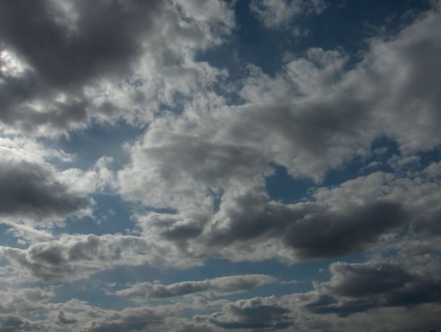
Kuva on otettu Espoon Tapiolassa kohti länsitaivasta ja kuvassa nähdään kumpukerrospilviksi levinneitä kumpupilviä. Tilanteessa vallitsi heikkenevä, mutta ajankohtaan nähden kylmä pohjoistuuli; iltapäivän lämpötila oli vain +10,9 astetta. Tuulen ja kylmyyden myötä merituulta ei juuri ollut, joten pilvet seilasivat myös meren ylle. Tuulia heikensi Grönlannista Suomen lounaispuolelle ulottunut korkeapaineen selänne, joka siirtyi seuraavaksi yöksi Etelä-Suomen päälle. Sen myötä lähes kaikki pilvet hajaantuivat ja yöstä tuli hyvin kylmä; lämpötila laski 2 metrin korkeudella jopa -2,4 asteeseen. Seuraavana päivänä kumpupilviä esiintyi hyvin vähän sisämaassa. Kylmälle ilmamassalle oli tyypillistä, että taivaan sinisyys oli vahvaa vähäisen kosteuden ansiosta ja kumpupilvien konvektio / termiikki oli heikkoa; pilvet jäivät mataliksi, kun lämpöä ei ollut riittävästi. Pilvet levisivät vaakasuunnassa kumpukerrospilviksi elinkaarensa lopussa, joka aiheutui näiden pilvien yläpuolelle syntyneestä inversiosta. Korkeapaineen alueella tällaisessa ilmamassassa usein käy niin. Lämpimässä ilmamassassa sopivan korkeapaineen alueella näin voi myös olla, kuten 4. toukokuuta kuvatuissa tilanteissa nähdään. Säätilanne: valitse 16.5.2006; Wetter3 A. Wetter3 B.
The picture is taken in the district of Tapiola in Espoo towards western sky and in the picture we see cumulus clouds turned into stratocumulus clouds. In the situation there prevailed calming, but unseasonally cold northerly wind; the afternoon temperature was only +10,9 C. Due to the winds and the coldness there wasn't sea breeze allmost at all, so the clouds drifted also over the sea. The winds were weakened by a ridge of high pressure, which reached southwestern side of Finland from Greenland. It moved over southern Finland the next night. Therefore allmost all clouds disappeared and the night was to be very cold; the temperature dropped in the height of 2 metres even to -2,4 C. During the next day there was very few cumulus clouds in inland areas. It was typical of the cold air mass, that the blueness of the sky was strong due to a small amount of moisture and the convection / thermal of the cumulus clouds was weak; the clouds remained flat as there wasn't enough warmth. The clouds spread in horizontal way into stratocumulus clouds at the end of their lifespan, which was resulted by an inversion formed on the upperside of these clouds. It usually happens in the high pressure during this kind of air mass. In the warm air mass in a suitable high pressure that can also be the case, as we see in the situations pictured in the 4th of May. Weather condition: choose 16.5.2006; Wetter3 A. Wetter3 B.
Helsingin Puistolan säätilasto toukokuussa 2006 - Weather chart of Puistola, Helsinki in May 2006.
Flickr 1 Flickr 2
Tehoisa lämpösumma - The Effective Temperature Sum: 127,5

posted by Mika at 4:54 PM
![]()


0 Comments:
Post a Comment
<< Home