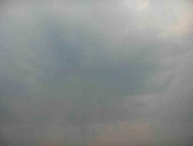
Tämä päivä oli pilvisyydeltään vaihteleva. Lähinnä vain untuva- ja harsopilviä esiintyi aluksi, mutta illalla lännestä lähestyneen vanhan ja heikkenevän okluusiorintaman runsas pilvisyys saapui kuvauspaikallekin. Tällöin kuvassa näkyvät kumpukerrospilvet ja hahtuvapilvet peittivät taivaan ajoittain melkein kokonaan. Jotkut osat kumpukerrospilvistä olivat kehittyneet heikoiksi kuuropilviksi tai itse asiassa ne olivat ko. rintaman heikkenevien sateiden jäänteitä; kuvassa nähdään heikkoja sadejuovia erään tällaisen pilven alla. Kuvauspaikallekaan ei silti saatu käytännössä ollenkaan sadetta. Ko. rintaman itäpuolella Suomeen virtasi etelästä yhä lämpimämpää ilmaa ja tänä päivänä ylin lämpötila oli +15,5 astetta huolimatta edellistä päivää runsaammasta pilvisyydestä. Utuakin oli ilmassa ja kuvassa se havaitaan noiden pilvien sinertävästä ja alempana taivaanrannassa myös ruskehtavasta sävystä; kyseessä ei vielä ollut iltaruskosävy, koska aurinko oli näinkin myöhään illalla vielä melko korkealla. Kesällä tällaisessa säätilanteessa olisi ukkosta. Kuva on otettu Espoon Tapiolassa koillistaivaalle. Säätilanne: valitse 2.5.2006; Wetter3 A. Wetter3 B.
During this day cloudyness was variable. At first mainly cirrus and cirrostratus clouds appeared, but in the evening plentyfull cloudyness of a old and weakening occluded front came also over the photoshooting scene. Then these stratoculumus and altocumulus clouds in the picture shadowed the sky occasionally allmost completely. Some parts of the stratocumulus clouds had been transformed into weak cumulonimbus clouds or actually they were remains of a weakening precipitation area associated with the mentioned front; in the picture we see weak rain stripes under one this kind of cloud. However also at the photoshooting scene as well there wasn't rain practically at all. On the eastern side of that front warmer air streamed further into Finland from the south and in this day the maximum temperature was +15,5 despite the more plentyfull cloudyness than in the previous day. There was also haze in the air and in the photo we can observe it from the blueish colour of those clouds and lower in the horizon also from the brownish colour tone; this wasn't yet sunset colour, because the sun was yet in a rather high position even so late in the evening. In summer during this kind of weather situation there would be thunder. The picture is taken in the district of Tapiola in Espoo towards northeastern sky. Weather condition: choose 2.5.2006; Wetter3 A. Wetter3 B.
Helsingin Puistolan säätilasto toukokuussa 2006 - Weather chart of Puistola, Helsinki in May 2006.
Flickr 1 Flickr 2
Tehoisa lämpösumma - The Effective Temperature Sum: 33,6

posted by Mika at 7:16 PM
![]()


0 Comments:
Post a Comment
<< Home