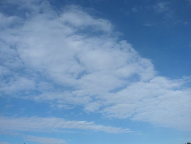
Etelä-Suomen ylle muodostunut pieni korkeapaine oli siirtymässä tässä tilanteessa itään ja Britteinsaarilla ja pohjoisella Atlantilla ollut laaja matalapaine useine keskuksineen lähestyi Suomea. Sen merkkinä etelätuuli alkoi vähitellen voimistua ko. päivänä ja pilvisyys runsastui. Kuvassa nähdään pilvilauttaa, joka koostui hyvin ohuista hahtuvapilvistä. Näitä pilviä esiintyy tyypillisesti minkä tahansa säärintaman lähestyessä kylmän ilmamassan vielä ollessa tarkastelupaikalla. Näiden pilvien mukana on yleensä myös untuva-, pallero-, harso- ja verhopilviä. Yhdessä ne merkitsevät usein lämpimän rintaman lähestymistä ja niin oli käymässä myös tässä tilanteessa. Yöhön mennessä ei kuitenkaan vielä satanut ja koko Suomi oli edelleen kylmän ilman alueella; päivälämpötila oli melko aurinkoisesta säästä huolimatta ko. päivänä vain +12,6 astetta ja yöllä oli ankaraa hallaa ja pakkasta monin paikoin. Illan myötä pilvistyneen sään takia hallaa ei kuitenkaan ollut enää seuraavana yönä. Kuva on otettu Espoon Tapiolassa pohjoistaivaalle. Säätilanne: valitse 18.5.2006; Wetter3 A. Wetter3 B.
A small high pressure formed over southern Finland was moving to the east at this situation and a large low pressure with many centers situated in British Isles and northern Atlantic was nearing Finland. As a mark for that a southerly wind started to pick up slowly during this day and clouds were increasing. In the picture we see a layer of clouds, which was composed of very thin altocumulus clouds. These clouds are appearing typically, when any kind of weather front is approaching as a cold air mass is yet at the observing scene. Among these clouds there are usually also cirrus, cirrocumulus, cirrostratus and altostratus clouds. Together they mark many times the approaching of a warm front and so was the case also in this situation. However it wasn't raining until the night and whole Finland was further in the area of the cold air mass; the afternoon temperature was only +12,6 C in this day despite the rather sunny weather and at night there was severe ground frost and frost in many places. However as the weather got cloudy during the evening there wasn't ground frost anymore during the next night. The picture is taken in the district of Tapiola in Espoo towards northern sky. Weather condition: choose 18.5.2006; Wetter3 A. Wetter3 B.
Helsingin Puistolan säätilasto toukokuussa 2006 - Weather chart of Puistola, Helsinki in May 2006.
Flickr 1 Flickr 2
Tehoisa lämpösumma - The Effective Temperature Sum: 131,4

posted by Mika at 5:26 PM
![]()


0 Comments:
Post a Comment
<< Home