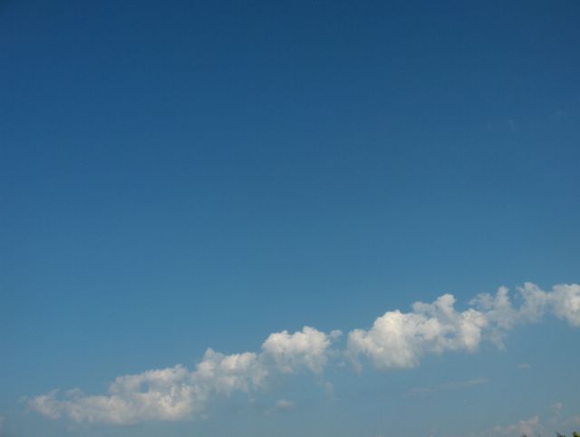
Muutama tunti myöhemmin samana päivänä verrattuna edelliseen kuvaan luoteesta lähestynyt kylmä rintama oli tässä vaiheessa tuonut jo selvemmin pilviä kuvauspaikalle. Kuvauspaikka oli tällä kertaa Helsingin Siltamäki ja kuvaussuunta oli kohti kaakkoistaivasta. Kuvassa oli tyypillinen vallinharjamainen hahtuvapilvinauha, joita esiintyy usein kesäaikana kylmän rintaman edellä. Kylmän rintaman konvektiota voimistava vaikutus näkyy esim. tällä tavalla ja monesti kylmän rintaman edellä olevat tällaiset pilvijonot kehittyvät ukkospilviksi, kun ilmassa on enemmän kosteutta. Kuvaajan takana oli lähinnä untuva- ja harsopilviä rintaman suuntaisena kilpenä ja rintaman kohdalla olleet kuuropilvet olivat vielä kaukana taivaanrannassa. Ne pilvet heikkenivät etelärannikolle tultuaan viileän meren (n. +15 astetta) ja laskevan auringon takia, jolloin sisämaassa paikoin ukkostakin tuoneista pilvistä satoi vain paikallisia vähäisiä kuuroja myöhemmin illalla ja yöllä. Länsilounainen tuuli oli ennen rintamaa voimakasta ja puuskaista, mutta rintaman kohdalla tuulet tyyntyivät yöksi. Säätilanne: valitse 14.6.2006; Wetter3 A. Wetter3 B.
A couple of hours later in the same day as compared to the previous photo the cold front approached from the northwest had allready been brought more obvious clouds into the photoshooting scene at this stage. The photoshooting scene was in this case in the district of Siltamäki in Helsinki and the direction of the photoshoot was towards southeastern sky. In the picture there was a typical band of altocumulus castellanus clouds, which appear many times in the foreside of a cold front during summer time. The cold front's strengthening effect to the convection is seen for example in this way and in many times these kinds of cloud bands in the foreside of the cold front evolve into thunderclouds / cumulonimbus clouds, when there's more moisture in the air. In the backside of the photographer there was mainly a shield of cirrus and cirrostratus clouds along the direction of the front and the cumulonimbus clouds at the place of the front were yet far away in the horizon. As those clouds came to the southern coast they weakened due to the cool sea (about +15 C) and the setting sun. Therefore the clouds that gave even thunder locally in inland areas brought only local slight showers later in the evening and at night. The west-southwesterly wind was strong and gusty before the front and in the place of the front winds calmed down until the night. Weather condition: choose 14.6.2006; Wetter3 A. Wetter3 B.
Helsingin Puistolan säätilasto kesäkuussa 2006 - Weather chart of Puistola, Helsinki in June 2006.
Flickr 1 Flickr 2
Tehoisa lämpösumma - The Effective Temperature Sum: 315,5

posted by Mika at 7:10 PM
![]()


0 Comments:
Post a Comment
<< Home