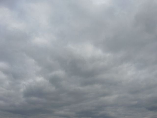
Pääasiassa tavanomaista viileämpi ja vaihtelevan pilvinen sää jatkui tämän kuun alussa; 3. päivänä satoi kohtalaisesti (sadepilvet), mutta muutoin vallitsivat lähinnä kumpukerros-, hahtuva-, kumpu- ja kuuropilvet (sisämaassa). Kuvan tilanteessa Etelä-Suomen kaakkoispuolelle oli asettunut melko voimakas matalapaine, jonka myötä ko. päivänä vallitsi voimakas ja viileä pohjois - koillistuuli. Sen myötä päivälämpötila jäi vain +12,7 asteeseen. Viileyttä tehosti kuvassa nähtävä pilvisyys, mutta pilvien ja tuulten ansiosta yöllä ei ollut hallaa; alin lukema oli +7,1 astetta. Nämä kumpukerrospilvet täyttivät taivaan päivän aikana ajoittain kokonaan ja merituulta ei ollut vaikuttamassa ko. pilviin ilmamassan kylmyyden ja matalapaineen vuoksi. Ilmamassa oli tyypiltään kuiva, jolloin pilvien muodot näkyivät hyvin vähäisen udun takia. Pilvikerros oli melko tasainen vähäisen konvektiivisen energian takia, koska oli viileää. Tämä pilvityyppi esiintyy tyypillisesti matalapaineen kylmällä sivulla lähellä sadealuetta silloin, kun sadealue liikkuu läheltä ohi tai ns. hidasliikkeisen kylmän rintaman jälkipuolella. Lämpimässä tai jopa helteisessä ilmamassassa kumpukerrospilvet olisivat kokkareisempia ja seassa olisi voimakkaita konvektiopilviä (kuuropilvet) eli paikoin esiintyisi sadekuuroja ja ukkosta; ilmamassa on siis silloin epävakaampi. Mitä lämpimämpi ilmamassa on niin sitä epävakaampi se yleensä on matalapaineen lähellä. Tässä tilanteessa ko. matalapaineen sadealue jäi tarkastelupaikan itäpuolelle. Kuva on otettu Espoon Tapiolassa etelätaivaalle. Säätilanne: valitse 6.6.2006; Wetter3 A. Wetter3 B.
Mainly cooler than normal and variably cloudy weather prevailed during the early part of this month; at the 3rd day it rained moderately (nimbostratus clouds), but otherwise there prevailed mostly stratocumulus, altocumulus, cumulus and cumulonimbus (in inland areas) clouds. In the situation of the picture a rather strong low pressure had been settled to the southeastern side of southern Finland, which resulted a strong and cool north - northeasterly wind during the day; the afternoon temperature stayed at only +12,7 C. The coolness was intensified by the layer of clouds seen in the picture, but due to the clouds and winds there wasn't ground frost during the night; the minimum reading was +7,1 C. These stratocumulus clouds covered the sky occasionally completely during the day and there wasn't a sea breeze affecting to these clouds due to the cool air mass and the low pressure. The air mass was dry in type and therefore the shapes of the clouds were finely visible due to a small amount of haze. The layer of clouds was rather even due to a small convective energy, because it was cool. This cloud type appears typically in the cool side of a low pressure near a precipitation area, as the precipitation area passes by or in the backside of a so called slow moving coldfront. In a warm or even hot air mass the stratocumulus clouds would be more lumpy and amongst them there would be strong convective clouds (cumulonimbus clouds). In other words there would be locally showers and thunder; the air mass would be therefore more unstable. The warmer the air mass is the more unstable it usually is, when situated near a lowpressure. In this case the precipitation area associated with the low pressure stayed eastside of this observation post. The picture is taken in the district of Tapiola in Espoo towards southern sky. Weather condition: choose 6.6.2006; Wetter3 A. Wetter3 B.
Helsingin Puistolan säätilasto kesäkuussa 2006 - Weather chart of Puistola, Helsinki in June 2006.
Flickr 1 Flickr 2
Tehoisa lämpösumma - The Effective Temperature sum: 235,5

posted by Mika at 4:40 PM
![]()


0 Comments:
Post a Comment
<< Home