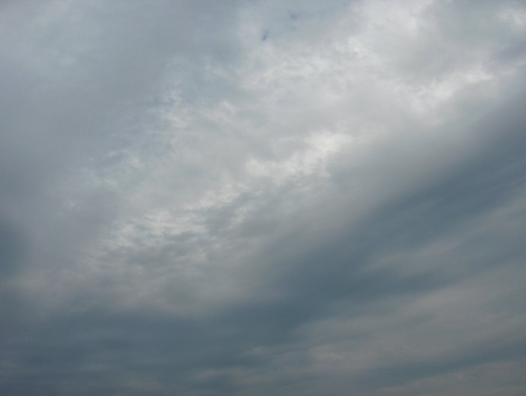
Kuvassa nähdään kumpukerros- ja hahtuvapilviä tilanteessa olleen kylmän rintaman kohdalla. Ne liikkuivat lounaasta koilliseen. Rintamaan liittyi vain paikoin ukkosta ja yksi ukkossolu oli kuvaushetkellä kaukana Helsingin itäpuolella ylittämässä Suomenlahtea. Tämä kuva on otettu Espoon Tapiolassa etelätaivaalle. Lämpimän sektorin (ko. helleilma) ilmamassa vaikutti silti vielä ja sää jatkui kuvauspaikalla edelleen helteisenä; edellisenä päivänä oli +30,5 astetta ja ko. päivänä +28,2 astetta. Kaikkein kuumin ilma (jopa n. +35 asteen lukemia) oli kuitenkin rajautumassa Suomen kaakkoispuolelle ko. rintaman myötä. Lounaistuulet olivat edelleen enimmäkseen heikkoja ja ilmamassa oli lämpimälle sektorille tyypillisesti edelleen hieman utuista. Sen takia nuo pilvet olivat hieman sinertäviä ja taivaanrannan vaaleat kohdat ruskehtavia. Nuo ko. pilvilajien muodot kertoivat epävakaasta troposfäärin tilasta, joka tyypillisesti vallitsee kylmän rintaman kohdalla ja lähellä sen etupuolella. Nämä aaltomaiset ja nauhamaiset muodot sekä konvektiiviset osat (kukkakaalimaiset kumpumuodot, joita oli kuvassa vaaleimmassa kohdassa alemman harmaan pilvikerroksen takana) em. udun aiheuttamien värien kanssa merkitsevät siten yleensä ukkosta tulevaksi. Tässä tapauksessa vähätkin ukkoset menivät reilusti tarkastelupaikan ohi ja edes sadetta ei tullut koko rintamasta. Säätilanne: valitse 9.7.2006; Wetter3 A. Wetter3 B.
In the picture we see altocumulus and stratocumulus clouds in the place of a cold front in the situation. They moved from the southwest to the northeast. There appeared only locally thunder in the cold front and at the time of the photoshoot one cell of thunder was far away in the eastern side of Helsinki crossing The Gulf Of Finland. This picture is taken in the district of Tapiola in Espoo towards southern sky. The air mass of the warm sector (the hot air in question) was affecting yet though and the weather continued further hot in the photoshooting scene; there was +30,5 C in the previous day and in this day +28,2 C. However the hottest air (readings of even about +35 C) was being bordered to the southeastern side of Finland due to the front. Southwesterly winds were further mostly weak and the air mass was further a little hazy typical of the warm sector. Therefore those clouds were a bit blueish and the light spots in the horizon brownish. Those shapes of these cloud types told about an unstable condition of the troposphere, which typically prevails in the place of a cold front and near in the foreside of it. These wavy and stripe-like shapes and also convective parts (the cauliflowery cumulus shapes, which appeared in the picture in the lightest spot behind the lower grey layer of clouds) along with the mentioned colours caused by haze are therefore usually meaning thunder to arrive. In this case also small thunderstorms as well passed widely this observation post and there didn't come even rain from the whole front. Weather condition: choose 9.7.2006; Wetter3 A. Wetter3 B.
Helsingin Puistolan säätilasto heinäkuussa 2006 - Weather chart of Puistola, Helsinki in July 2006.
Flickr 1 Flickr 2
Tehoisa lämpösumma - The Effective Temperature Sum: 671,7
posted by Mika at 4:26 PM
![]()


0 Comments:
Post a Comment
<< Home