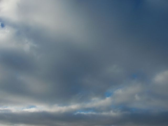
Edellisenä päivänä luoteesta saapuneen pienen matalapaineen rintamapilvisyys viipyili yhä edelleen heikkona Suomen yllä. Pilvisyys oli kuvauspäivänä aluksi verho- ja sadepilviä ja sitten untuva-, pallero- ja hahtuvapilviä kiinnostavina rintaman suuntaisina nauhoina. Tämä havaitaan hyvin Helsingin Siltamäessä itätaivaalle otetussa kuvassa. Siinä pilvilajeina olivat lähinnä kaksi viimeksi mainittua ja pilven osat liikkuivat pohjoisesta etelään selvällä nopeudella. Maan pinnalla oli kuitenkin lähes tyyntä. Edellisenä yönä oli satanut hyvin heikosti lunta. Ilmamassa oli kuivaa ja polaarista, jolloin sään seljettyä osaksi alin lämpötila oli illan loppuun mennessä -12,5 astetta. Päivällä aurinko lämmitti jo kohtuullisesti enteillen tulevaa kevättä; ylin lämpötila oli -0,1 astetta. Säätilanne: valitse 22.2.2006; Wetter3 A. Wetter3 B.The weather front cloudyness of a small low pressure arrived from the northwest during the previous day was still lingering weakly over Finland. The clouds during the day were altostratus and nimbostratus clouds at first and then cirrus, cirrocumulus and altocumulus clouds in interesting stripes according to the weather front. This is finely visible in the picture taken in the district of Siltamäki in Helsinki towards eastern sky. In there the cloud types were mostly the latter two of the mentioned and parts of the clouds were moving from the north to the south in a clear pace. However at the ground surface winds were allmost still. It had been snowed very slightly the night before. The air mass was dry and polaric and therefore after the weather got partly clear the minimum temperature was -12,4 C by the end of the evening. In the afternoon the sun warmed up the air allready moderately foreseeing the coming spring; the maximum temperature was -0,1 C. Weather condition: choose 22.2.2006; Wetter3 A. Wetter3 B.Helsingin Puistolan säätilasto helmikuussa 2006 - Weather chart of Puistola, Helsinki in February 2006.Flickr 1 Flickr 2
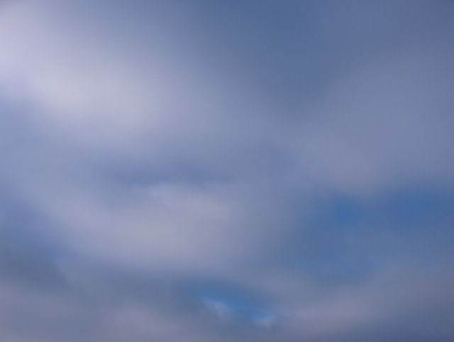
 Edellisen päivän sumupilvet olivat tässä vaiheessa kaikonneet lähes kokonaan, koska läntisen korkeapaineen pohjoispuolitse luoteesta oli virrannut paikalle kuivempaa ilmamassaa heikon tuulen myötä. Samalla ilma alkoi kylmetä vähän. Taivaalla olivat kuitenkin edelleen sekä vanhan etelässä olleen että luoteesta lähestyneen uuden säärintaman verhopilvet kilpimäisenä kerroksena. Pilviverhon paksuus ja tyyppi vaihtelivat päivän aikana ja hyvin heikkoa lumisadetta tuli ajoittain. Kuva on otettu Espoon Tapiolassa kohti kaakkoistaivasta. Säätilanne: valitse 21.2.2006; Wetter3 A. Wetter3 B.The stratus clouds of the previous day were allmost completely disappeared at this stage, because along the north side of a westerly high pressure drier air mass had flowed from the northwest to the scene with a weak wind. At the same time the air started to get colder a bit. In the sky though there were further altostratus clouds in a shieldlike layer associated with the old weather front in the south and a new front approaching from the northwest. The thickness and type of the cloud cover varied during the day and it snowed very slightly occasionally. The photo is taken in the district of Tapiola in Espoo towards southeastern sky. Weather condition: choose 21.2.2006; Wetter3 A. Wetter3 B.Helsingin Puistolan säätilasto helmikuussa 2006 - Weather chart of Puistola, Helsinki in February 2006.Flickr 1 Flickr 2
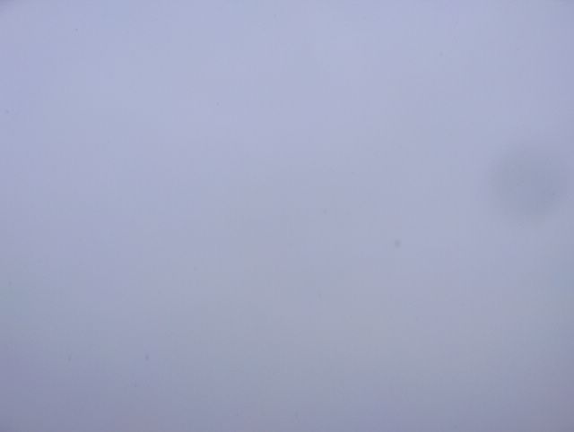
 Suomeen ulottui tässä vaiheessa heikot matalapaineet pohjoisesta ja etelästä. Edellisinä parina päivänä eteläinen ilmavirtaus oli lahduttanut sään niin, että kuvauspäivänä ylin lämpötila oli -1,0 astetta. Kuvassa nähdään melko tasaista sumupilvilauttaa, joka vallitsi hyvin hidasliikkeisenä tilanteen lähes tyynessä säässä. Pilvet johtuivat eteläisen ilmamassan kosteudesta. Pilvien takana piilossa oli jonkin verran matalapaineiden pilvisyyttä (mm. untuva- ja verhopilviä). Kuvausajankohta paljastaa auringonvaloa riittäneen vielä myöhään iltapäivällä, joten kohti kevättä oltiin menossa. Iltarusko oli kuitenkin havaittavissa jo selvästi. Kuva on otettu Espoon Tapiolassa kohti etelätaivasta. Säätilanne: valitse 20.2.2006; Wetter3 A. Wetter3 B.Weak low pressures were reaching Finland from the north and south at this stage. During previous couple of days a southerly air flow had made the weather milder in such way, that at the photoshooting day the temperature was -1,0 C at highest. In the picture we see rather even layer of stratus clouds, which prevailed in a very slow moving fashion during allmost still winds. The clouds were due to moisture of the southerly air mass. Behind the clouds there were hiding some amount of clouds (for example cirrus and altostratus clouds) associated with the low pressures. The shooting time of the photo reveals, that there were enough sunlight even late in the afternoon; towards the spring we were going. However the sunset colours were allready clearly visible. The picture is taken in the district of Tapiola in Espoo (near Helsinki) towards southern sky. Weather condition: choose 20.2.2006; Wetter3 A. Wetter3 B.Helsingin Puistolan säätilasto helmikuussa 2006 - Weather chart of Puistola, Helsinki in February 2006.Flickr 1 Flickr 2
 Samana päivänä vähän myöhemmin toiseen suuntaan kuvattuna nähdään, kuinka ko. kumpukerrospilvi alkoi vähetä, vaikka ko. rintama oli lähestymässä. Päivän mittaan pilvilauttoja saapui kuitenkin lisää ja ne olivat hyvin hidasliikkeisiä heikossa tuulessa ja hitaan rintaman ansiosta. Kuvassa nähdään myös se, kuinka jo korkeammalla olevan auringon takia iltapäivälläkään ei enää ollut näkyvillä mitään ilta- / aamuruskovärejä. Kevät oli siis lähestymässä. Kuva on otettu Espoon Tapiolassa kohti koillistaivasta. Säätilanne: valitse 13.2.2006; Wetter3 A. Wetter3 B.In the same day a little later as pictured to the other direction we see, how this stratocumulus cloud started to decrease, allthough the mentioned front was approaching. However during the day new layers of clouds were coming and they were very slow moving in the weak winds and due to the slow front. In the picture we see also, how there was no sunset / sunrise colours appearing even afternoon due to allready higher position of the sun. So the spring was nearing. The photo is taken in the district of Tapiola in Espoo (near Helsinki) towards northeastern sky. Weather condition: choose 13.2.2006; Wetter3 A. Wetter3 B.Helsingin Puistolan säätilasto helmikuussa 2006 - Weather chart of Puistola, Helsinki in February 2006.Flickr 1 Flickr 2
 Tässä on edelleen esimerkki kumpukerrospilvestä. Nyt tämä pilvilaji liittyi enemmän paikkaa lännestä lähestyneeseen heikkoon säärintamaan. Matalapaine ulottui pohjoisesta Suomeen. Kumpukerrospilvi on monesti hyvin mielenkiintoinen ja vaihteleva muodoiltaan. Tässäkin havaitaan jänniä osalauttoja ja raja-alueita. Rintaman ansiosta sää oli tilapaisesti aikaisempaa lauhempaa; ylin lämpötila oli päivän aikana -1,6 astetta, mutta nytkään ei ollut suojaa. Kuva on otettu Espoon Tapiolassa luoteistaivaalle. Säätilanne: valitse Base Time 13.2.2006. Wetter3 A. Wetter3 B. Here is further example of the stratocumulus cloud. Now this cloud type was more associated with a weak weather front that approached the scene from the west. A low pressure was reaching Finland from the north. The stratocumulus cloud is many times very interesting and variable in forms. In here as well we see exciting sublayers and borderlines. Due to the front the weather was temporarily milder than before; the maximum temperature was -1,6 C during the day, but there wasn't thaw even now. The picture is taken in the district of Tapiola in Espoo towards northwestern sky. Weather condition: choose Base Time 13.2.2006. Wetter3 A. Wetter3 B.Helsingin Puistolan säätilasto helmikuussa 2006 - Weatherchart of Puistola, Helsinki in february 2006.Flickr 1 Flickr 2
 Suomeen ulottui tässä vaiheessa korkeapaine lounaasta ja kaakosta; kuvauspaikka oli tyynessä korkeapaineen selänteessä. Ilmamassa oli edelleen selkeästi useita asteita pakkasella; lämpötila oli alimmillaan -8,9 astetta. Tällaisessa keskileveysasteiden ilmamassan korkeapaineessa kuvan kumpukerrospilvet ovat tyypillisiä loppusyksyllä ja talvella, kuten aikaisemmistakin vastaavan tilanteen kuvista nähdään. Tässä havaitaan silti, kuinka pakkasilmamassassa ko. pilvilaji oli selvästi sumeampi kuin Föhntuulitilanteessa 31. tammikuuta; pilvilaji muistutti nyt sumupilviä. Tämä johtui tämän pilven vesihöyryn kiteisemmästä muodosta. Myös aidot sumupilvet ovat tällaisissa tilanteissa tyypillisiä. Kuva on otettu Espoon Tapiolassa länsitaivaalle. Säätilanne: valitse 10.2.2006; Wetter3 A. Wetter3 B.At this stage a high pressure was reaching Finland from the southwest and southeast; the location was in the ridge of high pressure. The air mass was further several degrees freezing; the temperature was -8,9 C at lowest. In this kind of high pressure of the middle latitude air mass the stratocumulus clouds of the picture are typical during late autumn and winter in Finland as it's seen from the likewise situations in the previous photos. However in here we see, how during frosty air mass this cloud type was clearly more blurred than in the Föhn wind situation pictured at the 31th of January; the cloud type resembled now stratus clouds. This was due to more crystal form of this cloud's water vapour. Also actual stratus clouds are typical in this kinds of situations. The photo is taken in the district of Tapiola in Espoo towards western sky. Weather condition: choose 10.2.2006; Wetter3 A. Wetter3 B.Helsingin Puistolan säätilasto helmikuussa 2006 - Weather chart of Puistola, Helsinki in February 2006.Flickr 1 Flickr 2
 Verrattuna edelliseen kuvaan tässä nähdään, kuinka heikko lumisade ei näy juuri ollenkaan vasten taivasta. Vähäisen pilvisyyden aikana on toisin, kuten havaitaan 19. tammikuuta otetusta kuvasta. Pilvilajit olivat samat kuin edellisessä kuvassa ja sateen vähyyden vuoksi niiden muotoja näkyi jonkin verran. Tässä tilanteessa vallitsi heikko etelätuuli ja pakkasta oli lauhimmillaan -8,7 astetta. Matalapaine oli lounaassa Etelä-Skandinaviassa. Kuva on otettu Espoon Tapiolassa kohti etelätaivasta. Säätilanne: valitse 9.2.2006; Wetter3 A. Wetter3 B.As compared to the previous picture we see here, how a weak snowfall doesn't show against the sky allmost at all. During slight clouds it's a different story as it is seen in the picture taken the 19th of January. The cloud types were the same as in the previous photo and due to the minor amount of precipitation the forms of the clouds were showing a bit. In this situation a weak southerly wind prevailed and the air temperature was -8,7 C at highest. A low pressure was in the southwest in southern Skandinavia. The picture is taken in the district of Tapiola in Espoo (near Helsinki) towards southern sky. Weather condition: choose 9.2.2006; Wetter3 A. Wetter3 B.Helsingin Puistolan säätilasto helmikuussa 2006 - Weather chart of Puistola, Helsinki in February 2006.Flickr 1 Flickr 2
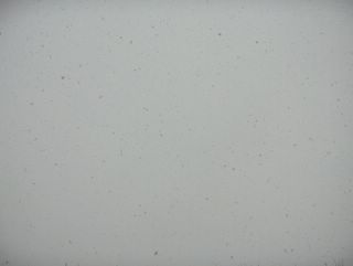 Luoteesta saapuneen pienen matalapaineen sadealue antoi hetkellisesti melko sankkaa lumisadetta, kuten kuvasta nähdään. Taivaan täyttämästä lumisateesta voidaan tehdä helposti päätelmiä sateen voimakkuudesta ja sateen aikaisista tuulioloista. Kuvan tilanteessa oli heikkotuulista, jolloin lumihiutaleet leijailivat tasaisesti. Itse pilvet (sade- ja sumupilvet) olivat tässä vaiheessa lumisateen sumentamia. Sää oli sadealueen myötä tilapäisesti lauhempaa; lämpötila oli ylimmillään -1,5 astetta päivän aikana. Kuva on otettu Vantaan Tikkurilassa pohjoistaivaalle. Säätilanne: valitse 1.2.2006; Wetter3 A. Wetter3 B.A precipitation area of a small low pressure arriving from the northwest gave momentarily rather dense snowfall as seen in the picture. Conclusions of the snowfall's density and wind conditions during the snowfall are easily made from the snowfall filled sky. In the situation of the photo winds were weak and therefore the snow-flakes floated evenly. The actual clouds (nimbus and stratus clouds) were blurred at this stage by the snowfall. The weather was temporarily milder due to the precipitation area; the temperature was -1,5 C at highest during the day. The photo is taken in the district of Tikkurila in Vantaa towards northern sky. Weather condition: choose 1.2.2006; Wetter3 A. Wetter3 B.Helsingin Puistolan säätilasto helmikuussa 2006 - Weather chart of Puistola, Helsinki in February 2006.Flickr 1 Flickr 2