Kuvassa nähdään lounaistaivaalla lähestynyttä untuvapilvikilpeä. Kuva on otettu Helsingin Kalliossa erään kerrostalon huipulla näköalatasanteelta. Ennen tätä tilannetta edellisen kuvan jälkeen 14. päivänä lännestä tulleen kylmän rintaman yhteydessä tuli joitakin heikkoja kuurosateita (mm. kuuro-, kumpukerros- ja hahtuvapilviä) Etelä-Suomessa. Sitten siitä lähtien 17. päivän alkuun oli selkeää tai melkein selkeää; lähinnä vähän untuvapilviä ja iltapäivän kumpupilviä vallinneessa kohtalaisessa pohjoistuulessa (etenkin 15. päivänä, kunnes tuuli tyyntyi). Kuun 17. päivän illasta 18. päivän iltapäivään asti pilvisyys oli jälleen runsasta (useimmat pilvilajit vaihtelevasti; vähiten sade- ja sumupilviä) lännestä muotoutuneen matalapaineen takia ja paikoin tuli sadekuuroja. Etelä-Suomen itäosa sai jopa runsasta kuurottaista sadetta, mutta esim. Helsingissä ei satanut. Sen jälkeen vallitsi samanlainen pohjoistuulitilanne kuin 14. - 17. päivinä. Kuvauspäivänä pohjoistuuli oli tyyntynyt korkeapaineen siirryttyä Suomen ylle. Länsi- ja Keski-Euroopassa 18. päivästä lähtien vaikuttanut hyvin kuuma ilmamassa (lämpötilat jopa yli +35 astetta) lähestyi lounaasta Suomea. Sen myötä Etelä-Skandinaviaan muodostui pieni matalapaine ja sen vähäisen lämpimän rintaman (ei merkitty karttaan Wetter3 B) etummaiset pilvet olivat juuri nuo kuvan untuvapilvet. Ilmamassan kuivuuden ansiosta pilvien muodot näkyivät hyvin. Edellisen helteen ja tilanteen jälkeen sää oli tähän mennessä tavanomaisen kesäinen lämpötiloiltaan; iltapäivälämpötilat enimmäkseen +20 - +25 astetta ja yölämpötilat n. +10 astetta. Lämpimintä oli 17. päivänä; +24,6 astetta. Säätilanne: valitse 20.7.2006; Wetter3 A. Wetter3 B.
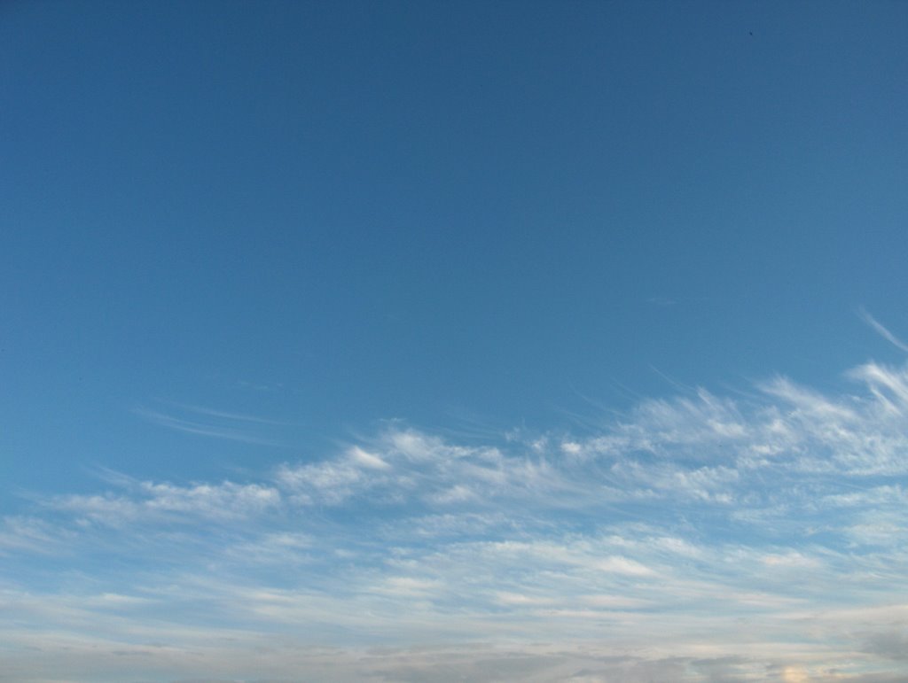
In the picture we see a shield of cirrus clouds approached in the southwestern sky. The picture is taken in the district of Kallio in Helsinki on the top of one high-rise building from a panorama terrace. Before this situation after the previous picture at the 14th day there came some weak showers (for example cumulonimbus, stratocumulus and altocumulus clouds) in southern Finland with a cold front arrived from the west. Then from there onwards to the early 17th day it was clear or mostly clear; mostly minor cirrus clouds and afternoon cumulus clouds in the prevailed northerly winds (especially during the 15th day until the wind calmed down). From the evening of the 17th day to the afternoon of the 18th day the cloudyness was profuse again (most of the cloud types in variable ways; nimbostratus and stratus clouds the least) due to a low pressure formed from the west and there came showers locally. The eastern part of southern Finland got showery rain even plentyfully, but for example it didn't rain in Helsinki. After that there prevailed a similar situation with northwesterly winds as between the 14th and the 17th days. In the photoshooting day the northerly wind had been calmed down as a high pressure moved over Finland. The very hot air mass (temperatures even more than +35 C) that affected western and middle Europe from the 18th day onwards approached Finland from the southwest. Due to that there formed a small low pressure in southern Skandinavia and the foremost clouds of its minor warm front (not marked on the map Wetter3 B) were just those cirrus clouds in the picture. Thanks to the drieness of the air mass shapes of the clouds appeared finely. Since the previous heatwave and situation the weather was usually summery concerning the temperatures; the afternoon temperatures mainly between +20 C and +25 C and the night temperatures about +10 C. In the 17th day it was the warmest; +24,6 C. Weather condition: choose 20.7.2006; Wetter3 A. Wetter3 B.
Helsingin Puistolan säätilasto heinäkuussa 2006 - Weather chart of Puistola, Helsinki in July 2006.
Flickr 1 Flickr 2
Tehoisa lämpösumma - The Effective Temperature Sum: 831
posted by Mika at 9:19 PM
![]()


0 Comments:
Post a Comment
<< Home