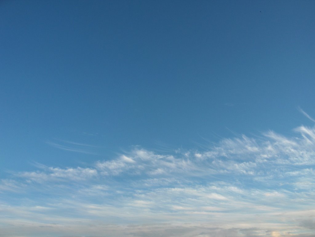
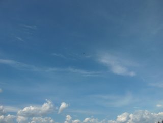
 Etelä-Suomen yllä oli edelleen kylmä rintama vielä 25. päivänä, mutta sadekuurot ja ukkoset olivat pääosin jo Suomen eteläpuolella. Pohjoiseen kääntynyt tuuli oli vielä hyvin heikkoa, jolloin helle jatkui; ylin lukema oli tuona päivänä +27,2 astetta. Seuraavasta päivästä lähtien pohjoistuulet kuitenkin voimistuivat Suomen länsipuolelle muodostuneen korkeapaineen ja Venäjällä jo pitkään vaikuttaneen matalapaineen voimistumisen takia. Pohjoistuulessa vallitsivat ajoittain lähinnä vähäiset untuvapilvet ja iltapäivisin matalat kumpupilvet. Ilmamassa myös kuivui, jolloin taivaan sinisyys näkyi voimakkaasti. Sää viileni ja 27. päivänä ylin lukema oli vain +21,5 astetta. Länsi- ja etenkin Keski-Euroopassa jo useita päiviä ollut hyvin helteinen ilmamassa yritti jälleen tulla Etelä-Suomeen kuvauspäivänä (se oli lähimmillään jo Etelä-Ruotissa) ja sen myötä lämmin rintama oli nyt lähestymässä lounaasta. Kuvassa nähdään ko. rintaman hyvin tyypillisiä pilviä kuvattuna Hämeenlinnassa lounaiselle taivaalle. Alhaalla (kauempana) oli rintaman suuntaisina raitoina verhopilviä ja ylhäällä (lähempänä) oli lähinnä harsopilveä. Tässä järjestyksessä lämpimän rintaman pilvet tyypillisesti juuri lähestyvät: untuvapilvet - harsopilvet - verhopilvet - sadepilvet. Alimpana nähtävät pilvet olivat lähes 100 kilometrin päässä; korkealla olevat pilvet näkyvät kuivassa (kirkkaassa) ilmassa kaukaa. Em. korkeapaine oli nyt Suomen yllä (tyynet tyylet) ja jakautumassa etelään ja pohjoiseen, jolloin em. helleilmamassan pohjoisreunalla kehittynyt matalapaine alkoi liikkua Suomen eteläpuolelle Etelä-Ruotsista em. rintaman kera. Pohjoiseen muotoutunut korkeapaine esti helleilman pääsyn Suomeen ja niinpä rintama ja kuvan pilvivyöhyke eivät tulleet enää juuri lähemmäksi (vain lounaisin kolkka Suomesta sai vähän sadetta). Säätilanne: valitse 28.7.2006; Wetter3 A. Wetter3 B.Over southern Finland there was further a cold front yet during the 25th day, but showers and thunderstorms were allready mostly in the southern side of Finland. The northerly wind turned to the north was yet very weak and so the heatwave continued; the maximum reading was +27,2 C in that day. However the northerly winds picked up from the next day onwards due to a high pressure formed in the western side of Finland and due to the strengthening of a low pressure that had allready been affected for a long time over Russia. In the northerly winds there prevailed occasionally only minor cirrus clouds and during afternoons flat cumulus clouds. The air mass also dried up, so the blueness of the sky was strongly visible. The weather turned cooler and in the 27th day the maximum reading was only +21,5 C. The hot air mass in the western and especially in the middle Europe affected those areas for several days allready and it tried again to come into southern Finland during the photoshooting day (it was in southern Sweden at the closest allready) and due to that a warm front was approaching now from the southwest. In the picture we see very typical clouds of that front as pictured in Hämeenlinna towards southwestern sky. Underneath (further away) there was altostratus clouds as stripes along the direction of the front and above (closer) there was mainly cirrostratus clouds. Just in this order the clouds of a warm front typically arrive: cirrus clouds - cirrostratus clouds - altostratus clouds - nimbostratus clouds. The clouds undermost were allmost 100 kilometres away; clouds in a high altitude are visible from great distances in a dry (clear) air. The mentioned high pressure was now over Finland (calm winds) and dividing into half to the south and to the north, when in the edge of the mentioned hot air mass a formed low pressure started to move from southern Sweden to the southern side of Finland with the mentioned front. The high pressure formed to the north prevented the hot air from arriving into Finland and so the front and the zone of clouds in the picture weren't moving hardly closer anymore (only the most southwestern corner of Finland got a little rain). Weather condition: choose 28.7.2006; Wetter3 A. Wetter3 B.Helsingin Puistolan säätilasto heinäkuussa 2006 - Weather chart of Puistola, Helsinki in July 2006.
Flickr 1 Flickr 2Tehoisa lämpösumma - The Effective Temperature Sum: 935
 Tämä kuva päättää tämän kuvasarjan saman ukkosalueen vaiheista ja se on otettu kohti etelätaivasta Espoon Tapiolassa. Siinä nähdään ko. ukkospilvijäänteen reunaa. Se oli siis käytännössä verhopilveä, joka edelleen heiketessään muuttuu untuvapilveksi. Muut alemmat ukkospilven osat muuttuvat kumpukerros- ja hahtuvapilviksi. Edellisen kuvan matelipilvi oli siitä esimerkki. Ukkospilven heikkeneminen tässä vaiheessa johtui osaltaan auringon säteilyn poistumisesta auringon laskiessa; auringon säteily on iso osa konvektiivisten virtausten kehittymisessä, jos rintaman aiheuttama konvektio ei ole voimakasta. Yhtenä syynä oli myös se, että pilvisysteemi lähestyi suhteellisen viileää (kuitenkin n. +20 asteinen) Suomenlahtea. Ko. rintama jäi edelleen eteläisen Suomen ylle. Säätilanne: valitse 24.7.2006; Wetter3 A. Wetter3 B.
This picture ends this five picture series of the same thunder area's phases and it's taken towards southern sky in the district of Tapiola in Espoo. In there we see the edge of the thundercloud (cumulonimbus cloud) remain in question. So it was an altostratus cloud in practise, which turns into cirrus clouds as it further dissipates. Other lower parts of the thundercloud transforms into stratocumulus and altocumulus clouds. The almond cloud in the previous picture was an example of that. The weakening of the thundercloud was resulted at this stage partly by the disappearing of the sun radiation as the sun was setting; the radiation of the sun plays a big role in the formation of convective air flows, if the convection caused by the front isn't strong. One reason was also the fact, that the cloud system was approaching relatively cool (however about +20 C) The Gulf Of Finland. The front in question remained further over southern Finland. Weather condition: choose 24.7.2006; Wetter3 A. Wetter3 B.
Helsingin Puistolan säätilasto heinäkuussa 2006 - Weather chart of Puistola, Helsinki in July 2006.
Flickr 1 Flickr 2
Tehoisa lämpösumma - The Effective Temperature Sum: 878,3
 Vain vähän edellisen kuvan jälkeen kuvattu otos kohti luoteistaivasta näytti mantelimaisen pilvimuodon laajaksi kilveksi levinneen ukkospilven jäänteen alueella. Kyseessä oli kumpukerros - hahtuvapilviin luokiteltava alalaji, joka kertoi ilmamassassa edelleen olleen epävakautta kylmän rintaman oltua lähellä pohjoisessa. Tämä vaihe illasta näytti jo vähän iltaruskosävyjä, koska aurinko oli melkein laskemassa. Nyt oli kulunut noin kuukausi kesäpäivänseisauksesta ja sen myötä yöt olivat tummuneet; auringon laskuaika (klo. 22.12) oli nyt noin 40 minuuttia aikaisemmin kuin kuukausi sitten. Tämä ajankohta on kuitenkin keskimäärin kesän lämpimintä aikaa eteläisessä Suomessa. Säätilanne: valitse 24.7.2006; Wetter3 A. Wetter3 B.
This photo taken only little after the previous picture towards northwestern sky showed an almond-like cloud shape in the area of the thundercloud remain spreaded into a wide plate. The cloud in question was classified as a subtype of stratocumulus - altocumulus clouds and it was showing there was further unstable properties in the air mass as the cold front was near in the north. This stage of the evening showed allready a bit of sunset colours as well, because the sun was allmost setting. Now there had been gone about a month since the summer solstice and due to that nights had been darkened; the setting time of the sun (10.12 pm) was now about 40 minutes earlier than about a month ago. However this time of the year is on an average the warmest time of summer in southern Finland. Weather condition: choose 24.7.2006; Wetter3 A. Wetter3 B.
Helsingin Puistolan säätilasto heinäkuussa 2006 - Weather chart of Puistola, Helsinki in July 2006.
Flickr 1 Flickr 2
Tehoisa lämpösumma - The Effective Temperature Sum: 878,3
 Melkein kolme tuntia myöhemmin ukkonen oli kuollut kokonaan ko. pilvestä sen heikennyttyä edelleen. Pilvialue ei ehtinyt tulla kuvauspaikan päälle ukkosvaiheisena ennen sitä, koska se oli niin hidasliikkeinen. Pilvialue laajeni kuitenkin tässä ehtoopuolen vaiheessa laajaksi verhopilveä muistuttavaksi pilvilaataksi. Tässä vaiheessa pilvi kattoi alueella melkein koko taivaan. Kuvassa nähdään erästä sen aaltomaista osaa; joissakin tilanteissa tässä vaiheessa tällaisilla kohdilla näkyisi näyttäviä mammatuspilviä. Kuva on otettu melkein keskelle taivasta itäpainotteisesti. Konvektiiviset kumpuosat olivat kadonneet ainakin n. tunti sitten. Pilvisysteemin sadekin oli jo melkein lakannut, mutta tälle alueella sadetta ei tullut joka tapauksessa; sadekuurot menivät itäkautta ohi. Säätilanne: valitse 24.7.2006; Wetter3 A. Wetter3 B.
Allmost three hours later the thunder had died out completely from the cloud as it weakened further. The cloud area didn't have time to arrive over the photoshooting scene in a thundery stage before that, because it was so slow moving. However the cloud area spreaded in this late phase into a wide cloud plate, which resembled altostratus clouds. At this stage the cloud was covering allmost the whole sky in the area. In the picture we see one undulating part of that; in some cases at this phase there would be present showy mammatus clouds in these kinds of spots. The picture is taken allmost towards the sky's zenith emphasizing to the east. The convective cumulus parts were disappeared at least about an hour ago. The precipitation of the cloud system had allmost been ended as well, but in this area there didn't come any rain in any case; the showers passed by from the eastern side. Weather condition: choose 24.7.2006; Wetter3 A. Wetter3 B.
Helsingin Puistolan säätilasto heinäkuussa 2006 - Weather chart of Puistola, Helsinki in July 2006.
Flickr 1 Flickr 2
Tehoisa lämpösumma - The Effective Temperature Sum: 878,3
 Yli tuntia myöhemmin ko. ukkospilvialue oli lähestynyt jo siten, että jyrinää oli kuulunut jo ainakin puolen tunnin ajan. Samalla tämä pilvisysteemi oli kuitenkin jo heikkenemässä ja salamoita näkyi vain hyvin harvakseltaan. Kuvan alareunassa nähdään ko. pilven tummaa alaosaa kuvattuna pohjoistaivaalle. Lievän udun takia tältä etäisyydeltä (n. 20 km) se näytti tämän verran sinertävältä. Alimpana näkyi pilven alla ollutta sadejuova-aluetta. Ylemmät vaaleat kokkareet olivat heikentyvien konvektiivisten ilmavirtausten katoavia kumpuosia. Siitä ylöspäin nähdään kuitumaisen alasinosan alareunaa. Säätilanne: valitse 24.7.2006; Wetter3 A. Wetter3 B.
More than an hour later this thundercloud area had been approached in such a way, that the sounds of thunder had been reached the scene for at least a half an hour. However at the same time this cloud system was allready weakening and there was lightning only very seldom. In the lower edge of the picture we see the dark lower part of the cloud as pictured towards northern sky. Due to slight haze it looked that much blueish from this distance (about 20 kilometres). The lowest there was present the precipitation stripe area under the cloud. The upper light lumps were dissappearing cumulus parts of the weakening convective air flows. Up from there we see the lower area of the fibrous anvil part. Weather condition: choose 24.7.2006; Wetter3 A. Wetter3 B.
Helsingin Puistolan säätilasto heinäkuussa 2006 - Weather chart of Puistola, Helsinki in July 2006.
Flickr 1 Flickr 2
Tehoisa lämpösumma - The Effective Temperature Sum: 878,3
 Tämä yllä oleva viiden kuvan sarja näyttää tilanteessa kehittyneen ukkospilvialueen vaiheita. Ko. iltapäivällä ja illalla eteläisessä Suomessa ukkosti melkein yhtä paljon kuin tämän kuun 10. päivänä. Kuvat on kuvattu Espoon Tapiolassa ja ne ovat tässä kronologisessa järjestyksessä. Edellisen kuvan jälkeen edellisenä päivänä lounaasta kohti Etelä-Suomea ulottui pieni korkeapaineen selänne, joka toi lounaasta ja lännestä lämpimämpää ilmaa. Kesän kuudes helleaalto alkoi sen myötä ja kuvauspäivänä iltapäivän lämpötila oli jo +25,8 astetta. Ko. päivänä pohjoisesta lähestyi hitaasti kylmä rintama ja tuulet olivat kääntymässä luoteeseen - pohjoiseen; tilanteen kehittymistä auttoi Venäjällä pyörinyt voimakas matalapaine. Ilmavirtaus oli Suomessa kuitenkin vielä hyvin heikkoa ja siten ko. rintaman ylitys oli vaivalloista. Helteinen ja aikaisempaa vähän kosteampi ilmamassa suosi silti kylmän rintaman etupuolella ukkossolujen kehittymistä. Tässä luoteeseen kuvatussa näkymässä nähdään eräs niistä. Se oli tässä kypsässä vaiheessa, jossa oli sekä kuitumaisia alasinosia että vielä konvektiivisia kumpuosia. Sen etäisyys kuvaajaan oli nyt n. 30 - 50 kilometriä ja jyrinää ei kuulunut pilvestä alueelle vielä lähes ollenkaan. Pilvisysteemi liikkui itäkaakkoon. Säätilanne: valitse 24.7.2006; Wetter3 A. Wetter3 B.
This series of five pictures above shows stages of a thunderstorm area formed in the situation. During this day's afternoon and evening there was thunder in southern Finland allmost equally as much as in the 10th day of this month. The pictures are photographed in the distric of Tapiola in Espoo and they are in chronological order in here. After the previous photo in the previous day there reached a small ridge of high pressure from the southwest towards southern Finland and that brought warmer air from the southwest and west. Due to that the sixth heatwave of the summer started and in the photoshooting day the afternoon temperature was allready +25,8 C. During this day there approached slowly a cold front from the north and the winds were turning to the northwest - north; the situation was helped by a strong low pressure that circulated over Russia. However the flow of the air was yet very weak in Finland and therefore the crossing of the front was laboured. The hot and a bit more moist air mass than before favoured though formations of thunder cells in the foreside of the cold front. In this scene taken towards northwestern sky we see one of them. It was in a mature stage in here, where there were both fibrous anvil parts and yet convective cumulus parts. Its distance from the photographer was now about 30 to 50 kilometres and there wasn't sounds of thunder reaching the scene allmost at all yet. The cloud system was moving towards the east-southeast. Weather condition: choose 24.7.2006; Wetter3 A. Wetter3 B.
Helsingin Puistolan säätilasto heinäkuussa 2006 - Weather chart of Puistola, Helsinki in July 2006.
Flickr 1 Flickr 2
Tehoisa lämpösumma - The Effective Temperature Sum: 878,3
 Tämä kuva on otettu Hämeenlinnassa myöhemmin illalla samana päivänä kuin edellinen kuva. Kuvaussuunta on kohti lounaistaivasta. Kuvassa olivat hahtuvapilvet, jotka esiintyivät tyypillisesti aikaisemmin aamulla olleen sadealueen jälkipuolella ja sen jäänteinä. Ilmavirtaukset olivat edelleen hyvin heikkoja ja siten ilmamassa Etelä-Suomenkin yllä oli hitaassa liikkeessä ja suorastaan seisoi melkein paikallaan; pilvet liikkuivat hitaasti kaakkoon. Tällainen tilanne suosii usein tällaisia laajoja vaakasuuntaisesti kehittyneitä pilvikerroksia. Tilanteen suhteellisen viileän ilmamassan takia edes iltapäivän aikana konvektiiviset kumpu- ja kuuropilvet eivät esiintyneet kunnolla. Niitä pilviä tosin oli vielä vähän näkyvissä kaakkoisella taivaanrannalla, jonne em. sadealue heikentyen siirtyi. Hahtuvapilvet ovat erinomaisia iltaruskopilviä, kuten tämän kuun 1. päivän kuvista nähdään. Tänä iltana sää kuitenkin selkeni lähes tyystin ennen auringon laskua. Säätilanne: valitse 22.7.2006; Wetter3 A. Wetter3 B.
This picture is taken in Hämeenlinna later in the evening at the same day as the previous picture. The direction of the photo is towards southwestern sky. There was altocumulus clouds in the picture and they appeared typically in the afterside of the precipitation area of the morning and as remains of that. The air flows were further very weak and so the air mass also over southern Finland was moving slowly and it practically remained almost in place; the clouds were moving slowly towards the southeast. This kind of situation favors many times these kinds of wide horizontally evolved layers of clouds. Due to the relatively cool air mass of the situation convective cumulus and cumulonimbus clouds weren't appearing properly even during the afternoon. Those clouds appeared yet a little in the southeastern horizon though, where the mentioned precipitation area moved weakening at the same time. Altocumulus clouds are excellent clouds for sunset colours as we can see from the pictures taken at the 1st day of this month. However during this evening the weather turned allmost clear before the sunset. Weather condition: choose 22.7.2006; Wetter3 A. Wetter3 B.
Helsingin Puistolan säätilasto heinäkuussa 2006 - Weather chart of Puistola, Helsinki in July 2006.
Flickr 1 Flickr 2
Tehoisa lämpösumma - The Effective Temperature Sum: 851,2
 Etelä-Skandinaviaan muodostunut pieni matalapaine oli tässä vaiheessa liikkunut itään Suomen eteläpuolelle. Sen takia Keski-Euroopassa ollut hyvin kuuma ilmamassa ei saapunut Suomeen, vaan se jäi matalapaineen eteläpuolelle. Päivälämpötilat jäivät siten edelleen vain n. +20 asteeseen. Kuumaa ilmamassaa rajaavat rintamat olivat melko epämääräisiä (Wetter3 B kartassa ei kaikkia näitä raja-alueita merkitty), koska pienten ilmanpaine-erojen vuoksi ilmavirtaukset ja siten ilmamassojen liikkeet olivat hitaita. Rintamien kohdille muodostui kuitenkin sadealueita, joista suurin osa liikkui Suomen eteläpuolella. Sinne jäivät myös ankarat ukkoset kuumaan ilmamassaan liittyen. Edellisenä päivänä yksi sadealue (jonka untuvapilvivyöhyke näkyi edellisessä kuvassa) tosin hipoi eteläistä Suomea ja samaan aikaan Länsi-Suomessa kehittynyt pieni sadealue jäi Etelä-Suomen ylle antaen ko. aamuna vähän sadetta kuvauspaikalle Espoon Tapiolaan. Kuva on otettu pohjoistaivaalle ja siinä nähdään ns. laajaa sadepilveä. Yläreunassa oli tummina kokkareina repaleisia sumupilviä (liittyvät usein tilanteeseen). Alhaalla keskellä nähdään vaaleana konvektiivisempaa pilvikerroksen osaa, josta satoi rankemmin siellä. Laajan sadepilvikerroksen seassa helteiseen ilmamassaan liittyen tällaiset konvektiiviset osat voivat kasvaa ukkosiksi asti. Nyt ei ollut niin. Sadealue oli liikkumassa kaakkoon heikentyen ja tyypillisesti siinä vaiheessa nämä pilvet alkoivat muuttua kumpukerros- ja hahtuvapilvien suuntaan. Säätilanne: valitse 22.7.2006; Wetter3 A. Wetter3 B.
The small low pressure formed in southern Skandinavia had now been moved eastwards to the southern side of Finland. Due to that the hot air mass prevailed in middle Europe didn't arrive in Finland, but it remained southern side of the low pressure. Therefore the afternoon temperatures stayed further only at about +20 C. Fronts that bordered the hot air mass were rather indefinite (all these borderlines weren't marked on the Wetter3 B map), because due to small differences in the air pressure air flows and so the movements of the air masses were slow. However there formed precipitation areas in the places of the fronts. Most of them moved in the southern side of Finland and also severe thunderstorms associated with the hot air mass remained there. During the previous day one precipitation area (which cirrus clouds appeared in the previous photo) verged on southern Finland though and at the same time a precipitation area formed in western Finland remained over southern Finland and it gave a little rain in the photoshooting scene the district of Tapiola in Espoo during this morning. The picture is taken towards northern sky and we see in there nimbostratus clouds. In the upper edge there were as dark lumps ragged stratus clouds (related often with the situation). Below in the middle we see as a light spot in the cloud layer a more convective part, which gave heavier rain there. Among a wide layer of nimbostratus clouds these kinds of convective parts can grow into thunderstorms (cumulonimbus clouds) when associated with a hot air mass. Now it wasn't the case. The precipitation area was moving towards the southeast weakening at the same time and typically at that phase these clouds were started to transform into stratocumulus and altocumulus clouds. Weather condition: choose 22.7.2006; Wetter3 A. Wetter3 B.
Helsingin Puistolan säätilasto heinäkuussa 2006 - Weather chart of Puistola, Helsinki in July 2006.
Flickr 1 Flickr 2
Tehoisa lämpösumma - The Effective Temperature Sum: 851,2
 Kuvassa nähdään lounaistaivaalla lähestynyttä untuvapilvikilpeä. Kuva on otettu Helsingin Kalliossa erään kerrostalon huipulla näköalatasanteelta. Ennen tätä tilannetta edellisen kuvan jälkeen 14. päivänä lännestä tulleen kylmän rintaman yhteydessä tuli joitakin heikkoja kuurosateita (mm. kuuro-, kumpukerros- ja hahtuvapilviä) Etelä-Suomessa. Sitten siitä lähtien 17. päivän alkuun oli selkeää tai melkein selkeää; lähinnä vähän untuvapilviä ja iltapäivän kumpupilviä vallinneessa kohtalaisessa pohjoistuulessa (etenkin 15. päivänä, kunnes tuuli tyyntyi). Kuun 17. päivän illasta 18. päivän iltapäivään asti pilvisyys oli jälleen runsasta (useimmat pilvilajit vaihtelevasti; vähiten sade- ja sumupilviä) lännestä muotoutuneen matalapaineen takia ja paikoin tuli sadekuuroja. Etelä-Suomen itäosa sai jopa runsasta kuurottaista sadetta, mutta esim. Helsingissä ei satanut. Sen jälkeen vallitsi samanlainen pohjoistuulitilanne kuin 14. - 17. päivinä. Kuvauspäivänä pohjoistuuli oli tyyntynyt korkeapaineen siirryttyä Suomen ylle. Länsi- ja Keski-Euroopassa 18. päivästä lähtien vaikuttanut hyvin kuuma ilmamassa (lämpötilat jopa yli +35 astetta) lähestyi lounaasta Suomea. Sen myötä Etelä-Skandinaviaan muodostui pieni matalapaine ja sen vähäisen lämpimän rintaman (ei merkitty karttaan Wetter3 B) etummaiset pilvet olivat juuri nuo kuvan untuvapilvet. Ilmamassan kuivuuden ansiosta pilvien muodot näkyivät hyvin. Edellisen helteen ja tilanteen jälkeen sää oli tähän mennessä tavanomaisen kesäinen lämpötiloiltaan; iltapäivälämpötilat enimmäkseen +20 - +25 astetta ja yölämpötilat n. +10 astetta. Lämpimintä oli 17. päivänä; +24,6 astetta. Säätilanne: valitse 20.7.2006; Wetter3 A. Wetter3 B.
In the picture we see a shield of cirrus clouds approached in the southwestern sky. The picture is taken in the district of Kallio in Helsinki on the top of one high-rise building from a panorama terrace. Before this situation after the previous picture at the 14th day there came some weak showers (for example cumulonimbus, stratocumulus and altocumulus clouds) in southern Finland with a cold front arrived from the west. Then from there onwards to the early 17th day it was clear or mostly clear; mostly minor cirrus clouds and afternoon cumulus clouds in the prevailed northerly winds (especially during the 15th day until the wind calmed down). From the evening of the 17th day to the afternoon of the 18th day the cloudyness was profuse again (most of the cloud types in variable ways; nimbostratus and stratus clouds the least) due to a low pressure formed from the west and there came showers locally. The eastern part of southern Finland got showery rain even plentyfully, but for example it didn't rain in Helsinki. After that there prevailed a similar situation with northwesterly winds as between the 14th and the 17th days. In the photoshooting day the northerly wind had been calmed down as a high pressure moved over Finland. The very hot air mass (temperatures even more than +35 C) that affected western and middle Europe from the 18th day onwards approached Finland from the southwest. Due to that there formed a small low pressure in southern Skandinavia and the foremost clouds of its minor warm front (not marked on the map Wetter3 B) were just those cirrus clouds in the picture. Thanks to the drieness of the air mass shapes of the clouds appeared finely. Since the previous heatwave and situation the weather was usually summery concerning the temperatures; the afternoon temperatures mainly between +20 C and +25 C and the night temperatures about +10 C. In the 17th day it was the warmest; +24,6 C. Weather condition: choose 20.7.2006; Wetter3 A. Wetter3 B.
Helsingin Puistolan säätilasto heinäkuussa 2006 - Weather chart of Puistola, Helsinki in July 2006.Flickr 1 Flickr 2
Tehoisa lämpösumma - The Effective Temperature Sum: 831
 Edellisen tilanteen jälkeen helteinen sää jatkui edelleen, mutta vähitellen viileten; kuvauspäivänä oli vielä +25,1 astetta ylimmillään. Vähäisen viilenemisen aiheuttivat pohjoisella Atlantilla voimistuneet matalapaineet ja niiden rintamat. Kuun 10. päivänä yksi matalapaine liikkui voimistuen pohjoisen Skandinavian yli itään. Sen kylmä rintama aiheutti tuolloin ankaria ukkosia etenkin itäiseen Suomeen. Kuvauspaikalla Espoon Tapiolassa rintaman ylityksessä ei ollut merkittäviä kuuropilviä (muistutti edellistä tilannetta). Myös edellisenä päivänä Suomen lännestä itään ylittäneessä rintamassa etelärannikolla oli lähinnä vain runsastunutta pilvisyyttä. Matalapaineiden eteläpuolella Atlantilta itään Suomen eteläpuolelle ulottui viime päivinä korkeapaineen alue, jolloin hyvin helteinen ilmamassa jäi paikalleen Suomen kaakkois- ja itäpuolelle. Sen vuoksi viileneminen oli vähäistä Etelä-Suomessa ja ilmankosteus väheni ilmamassojen vaihduttua rintamien myötä. Ko. päivänä Etelä-Suomi oli kahden rintaman välissä, jossa vallitsivat kuvan hahtuvapilvet selkeän yön jälkeen lännessä olleen rintaman lähestyttyä, kun Islannin tienoilla muodostunut voimakas matalapaine liikkui itään. Iltapäivällä hahtuvapilvien sekaan kehittyi kumpupilviä (ei meren yllä, mutta kuvassa vasemmalla ja ylhäällä). Ne eivät kehittyneet kunnolla (syynä oli mm. vähäinen ilmankosteus) hahtuvapilvikerroksen läpi, vaan ne sekoittuivat osittain ko. kerrokseen; tuloksena oli kumpukerrospilviä. Enintään kohtalaisen länsi - lounaistuulen takia pilvet liikkuivat hitaasti. Kuva on otettu Espoon Tapiolassa pohjoistaivaalle. Säätilanne: valitse 13.7.2006; Wetter3 A. Wetter3 B.
After the previous situation the weather continued further hot, but cooling down slowly; in the photoshooting day there was yet +25,1 C at highest. The slight cool down was caused by low pressures strengthened in northern Atlantic and their fronts. At the 10th day of the month one low pressure moved across northern Skandinavia to the east strengthening at the same time. The cold front of it caused at that time severe thunderstorms especially in eastern Finland. However in the photoshooting scene in the district of Tapiola in Espoo there wasn't notable cumulonimbus clouds in the crossing of the front (resembled the previous situation). Also during the previous day there was mainly just increased cloudyness by the southern coast in the front that crossed Finland from the west to the east. During last days in the southern side of the low pressures there was an area of high pressure reaching southern side of Finland, where due to that the very hot air mass remained in place in the southeastern and eastern side of Finland. Therefore the cooling was slight in southern Finland and the air moisture decreased as air masses changed due to the fronts. In the day in question southern Finland was between two fronts, where there prevailed altocumulus clouds in the picture after clear night as the front in the west approached, when a low pressure strengthened around Iceland moved eastwards. During the afternoon there formed cumulus clouds among the altocumulus clouds (not over the sea, but in the picture on the left and above). They didn't evolve properly (the reason being for example a low level of air moisture) through the layer of altocumulus clouds, but they mixed up with the layer partially; stratocumulus clouds were the result. Due to westerly - southwesterly winds moderate at the most the clouds moved slowly. The picture is taken in the district of Tapiola in Espoo towards northern sky. Weather condition: choose 13.7.2006; Wetter3 A. Wetter3 B.
Helsingin Puistolan säätilasto heinäkuussa 2006 - Weather chart of Puistola, Helsinki in July 2006.
Flickr 1 Flickr 2
Tehoisa lämpösumma - The Effective Temperature Sum: 739,2
 Kuvassa nähdään kumpukerros- ja hahtuvapilviä tilanteessa olleen kylmän rintaman kohdalla. Ne liikkuivat lounaasta koilliseen. Rintamaan liittyi vain paikoin ukkosta ja yksi ukkossolu oli kuvaushetkellä kaukana Helsingin itäpuolella ylittämässä Suomenlahtea. Tämä kuva on otettu Espoon Tapiolassa etelätaivaalle. Lämpimän sektorin (ko. helleilma) ilmamassa vaikutti silti vielä ja sää jatkui kuvauspaikalla edelleen helteisenä; edellisenä päivänä oli +30,5 astetta ja ko. päivänä +28,2 astetta. Kaikkein kuumin ilma (jopa n. +35 asteen lukemia) oli kuitenkin rajautumassa Suomen kaakkoispuolelle ko. rintaman myötä. Lounaistuulet olivat edelleen enimmäkseen heikkoja ja ilmamassa oli lämpimälle sektorille tyypillisesti edelleen hieman utuista. Sen takia nuo pilvet olivat hieman sinertäviä ja taivaanrannan vaaleat kohdat ruskehtavia. Nuo ko. pilvilajien muodot kertoivat epävakaasta troposfäärin tilasta, joka tyypillisesti vallitsee kylmän rintaman kohdalla ja lähellä sen etupuolella. Nämä aaltomaiset ja nauhamaiset muodot sekä konvektiiviset osat (kukkakaalimaiset kumpumuodot, joita oli kuvassa vaaleimmassa kohdassa alemman harmaan pilvikerroksen takana) em. udun aiheuttamien värien kanssa merkitsevät siten yleensä ukkosta tulevaksi. Tässä tapauksessa vähätkin ukkoset menivät reilusti tarkastelupaikan ohi ja edes sadetta ei tullut koko rintamasta. Säätilanne: valitse 9.7.2006; Wetter3 A. Wetter3 B.
In the picture we see altocumulus and stratocumulus clouds in the place of a cold front in the situation. They moved from the southwest to the northeast. There appeared only locally thunder in the cold front and at the time of the photoshoot one cell of thunder was far away in the eastern side of Helsinki crossing The Gulf Of Finland. This picture is taken in the district of Tapiola in Espoo towards southern sky. The air mass of the warm sector (the hot air in question) was affecting yet though and the weather continued further hot in the photoshooting scene; there was +30,5 C in the previous day and in this day +28,2 C. However the hottest air (readings of even about +35 C) was being bordered to the southeastern side of Finland due to the front. Southwesterly winds were further mostly weak and the air mass was further a little hazy typical of the warm sector. Therefore those clouds were a bit blueish and the light spots in the horizon brownish. Those shapes of these cloud types told about an unstable condition of the troposphere, which typically prevails in the place of a cold front and near in the foreside of it. These wavy and stripe-like shapes and also convective parts (the cauliflowery cumulus shapes, which appeared in the picture in the lightest spot behind the lower grey layer of clouds) along with the mentioned colours caused by haze are therefore usually meaning thunder to arrive. In this case also small thunderstorms as well passed widely this observation post and there didn't come even rain from the whole front. Weather condition: choose 9.7.2006; Wetter3 A. Wetter3 B.
Helsingin Puistolan säätilasto heinäkuussa 2006 - Weather chart of Puistola, Helsinki in July 2006.
Flickr 1 Flickr 2
Tehoisa lämpösumma - The Effective Temperature Sum: 671,7
 Edellisen tilanteen jälkeen helteisiin tuli lievä keskeytys 5. päivänä, kun kylmän rintaman jälkeen pohjoisesta virtasi heikosti ilmaa. Korkeapaine voimistui kuitenkin välittömästi lännestä ja sen asetuttua Suomen etelä- ja kaakkoispuolelle pääsi Länsi- ja Keski-Euroopassa ollut erittäin helteinen ilmamassa lounaasta Etelä-Suomeen. Ko. ilman päästessä Suomeen 6. päivän tienoilla esiintyi hieman untuva-, harso-, hahtuva- ja kumpukerrospilviä sekä keskisessä Suomessa paikoin kuuropilviäkin, mutta muutoin oli melkein koko ajan selkeää. Kuvassa nähdään sinistä taivasta, joka oli hieman vaalentunut ilmaa sameuttavan udun lisäännyttyä hieman kuvauspäiväksi. Se oli tyypillistä paikalle virranneelle keskileveysasteiden ilmamassalle. Hieman lisääntynyt ilmankosteus ei kuitenkaan ollut riittävää kumpupilvien kehittymiselle eteläisessä Suomessa. Ilman virtaaminen koko ajan heikosti - kohtalaisesti lounaasta pitkän Itämeren yli vaikutti myös asiaan; viileän meren (kuitenkin n. +20 asteinen) yltä tullessaan ko. ilmamassan konvektiiviset ominaisuudet heikentyivät. Kuvauspäivään mennessä helle voimistui silti jo niin, että monin paikoin koko Etelä-Suomessa ylitettiin +30 astetta tänä päivänä. Kuva on otettu Espoon Tapiolassa luoteistaivaalle. Säätilanne: valitse 7.7.2006; Wetter3 A. Wetter3 B.
After the previous picture there came a slight pause to the heatwave, as air flowed weakly from the north after the cold front. However a high pressure strengthened immediately from the west and as it settled in the southern and southeastern side of Finland a very hot air situated in western and central Europe had a chance to flow into southern Finland from the southwest. As this air reached Finland around the 6th day there appeared in minor amounts of cirrus, cirrostratus, altocumulus and stratocumulus clouds and in central Finland locally also cumulonimbus clouds, but otherwise it was allmost all the time clear. In the picture we see blue sky, which had been turned a little lighter as air blurring haze increased a bit until the photoshooting day. That was typical of the middle latitude air mass flown into the scene. However the slightly increased air moisture wasn't enough for the formation of cumulus clouds in southern Finland. Flowing of the air weakly - moderately all the time across the long Baltic Sea affected also to the matter; as the air mass came from over the cool sea (about +20 C though) its convective properties decreased. Until the photoshooting day the heatwave got stronger though in such a way, that in many places in southern Finland +30 C was topped during this day. The picture is taken in the district of Tapiola in Espoo towards northwestern sky. Weather condition: choose 7.7.2006; Wetter3 A. Wetter3 B.
Helsingin Puistolan säätilasto heinäkuussa 2006 - Weather chart of Puistola, Helsinki in July 2006.
Flickr 1 Flickr 2
Tehoisa lämpösumma - The Effective Temperature Sum: 633,8
 Tämä kuva päättää Espoon Tapiolassa kuvatun saman päivän kuvasarjan. Sarja näyttää ko. päivänä Etelä-Suomen ylittäneen kylmän rintaman pilvisyyttä. Tässä vaiheessa n. viisi tuntia myöhemmin länsituuli oli tyyntynyt ja pohjoistaivaan kumpupilvivyöhyke oli kehittynyt paikallisiksi ukkoskuuroiksi. Niistä nähdään kuvassa yksi etäällä taivaanrannassa. Se oli tilanteessa yli 50 kilometrin päässä kuvaajasta, mutta korkeina pilvinä ukkospilvet näkyvät kauas; tämä pilvi ukkosti ko. iltana mm. Hämeenlinnassa ja se liikkui itäkaakkoon. Etäisyyden takia jyrinää ei kuulunut kuvauspaikalle koko pilven elinaikana. Tähän mennessä tätä pilvilajia oli esiintynyt sen verran vähän tänä kesänä, että vasta nyt minulla oli kunnon mahdollisuus kuvata sitä. Tuo pilvi oli ollut n. kolmen tunnin ajan kuuropilvivaiheessa ja nyt se oli jo heikkenemässä. Pilvi ei ollut erityisen voimakas ja tästä parin tunnin kuluttua se oli kuollut. Siitä jäi tyypillisesti vähän untuva-, hahtuva- ja kumpukerrospilviä, jotka siirtyivät kylmän rintaman mukana Suomen eteläpuolelle yön aikana. Säätilanne: valitse 4.7.2006; Wetter3 A. Wetter3 B.
This picture ends the photoseries of the same day taken in the district of Tapiola in Espoo. The series shows the cloudyness of the cold front that crossed southern Finland during this day. At this stage about five hours later the westerly wind had been calmed down and the zone of cumulus clouds in northern sky had been evolved into local thundershowers. In the picture we see one of them far away in the horizon. It was more than 50 kilometres away from the photographer, but as high clouds the cumulonimbus clouds are visible from big distances; this cloud brought thunder for example into Hämeenlinna during this evening and it moved to the east-southeast. Due to the distance there wasn't sound of thunder to be heard in the photoshooting scene during the whole lifespan of the cloud. Up to this moment there was so little of this cloud type appearing during this summer, that only now i had a proper chance at photographing it. That cloud had been allready about three hours at the cumulonimbus stage and now it was allready weakening. The cloud wasn't especially powerfull and couple of hours onwards from here it was dead. There remained typically a bit of cirrus, altocumulus and stratocumulus clouds from it, which moved along with the cold front to the southern side of Finland during the night. Weather condition: choose 4.7.2006; Wetter3 A. Wetter3 B.
Helsingin Puistolan säätilasto heinäkuussa 2006 - Weather chart of Puistola, Helsinki in July 2006.
Flickr 1 Flickr 2
Tehoisa lämpösumma - The Effective Temperature Sum: 584,6
 Tämä kuva on otettu vain viisi minuuttia myöhemmin kuin edellinen kuva. Tilanne oli siis käytännössä sama, mutta tässä nähdään ko. (Tapiola, Espoo) paikalta pohjoistaivaalle kuvattu näkymä. Siinä taivaanrannassa oli ko. kylmän rintaman kumpupilvivyöhyke, jossa ei vielä tässä vaiheessa ollut kuuropilviksi asti kehittyneitä kohtia näkyvissä. Tässä tilanteessa oli tulkintakysymys, missä kohtaa em. kylmä rintama itse asiassa oli; edellisen kuvan pilvien tai tämän kuvan pilvien kohdalla. Joka tapauksessa nämä kaksi pilvivyöhykettä olivat hyvin selkeästi erillään toisistaan. Kumpupilvien esiintymistä tosin heikensi merituuli, joten rintaman ylitys jäi täällä etelärannikolla lähinnä vain edellisen kuvan pilvilajien ylitykseksi siitäkin syystä. Säätilanne: valitse 4.7.2006; Wetter3 A. Wetter3 B.
This picture is taken only five minutes later than the previous picture. So the situation was the same in practice, but in here we see from the place in question (Tapiola, Espoo) a scene photographed towards northern sky. There in the horizon associated with the mentioned cold front there was a zone of cumulus clouds, where there wasn't visible yet at this phase spots evolved into cumulonimbus clouds. At this situation it was a question of interpretation where the cold front actually situated; in the place of the previous photo's clouds or the place of this photo's clouds. In any case these cloud zones were clearly apart from each other. The appearance of cumulus clouds was prevented by the sea breeze though and therefore the crossing of the front remained in here by the southern coast mainly as a crossing of the previous photo's clouds also due to that reason. Weather condition: choose 4.7.2006; Wetter3 A. Wetter3 B.
Helsingin Puistolan säätilasto heinäkuussa 2006 - Weather chart of Puistola, Helsinki in July 2006.
Flickr 1 Flickr 2
Tehoisa lämpösumma - The Effective Temperature Sum: 584,6
 Kuvassa nähdään harso- ja verhopilveä kuvattuna Espoon Tapiolassa kohti kaakkoistaivasta. Tämä kuva on osa yllä olevaa kolmen kuvan kronologista sarjaa. Edellisen kuvan jälkeen sää oli pääasiassa tyystin selkeää tähän asti, kun korkeapaine vaikutti Suomeen etelästä. Vain ajoittain ja paikoin oli untuvapilviä Suomen itärajalla olleesta rintamavyöhykkeestä. Sen itäpuolella virtasi pohjoisesta hyvin viileää ilmaa Venäjälle. Etelä-Suomessa olleen ilmamassan kuivuuden ja korkeapaineen takia kumpupilviä ei juuri esiintynyt edes sisämaassa termiikin ilmenemisen jäätyä heikoksi; pilvien tiivistymiskorkeus oli liian korkealla. Ko. päivänä eteläistä Suomea oli ylittämässä kylmä rintama luoteesta kaakkoon. Nuo pilvet olivat rintaman etupuolella ja niissä nähtävät raidat olivat rintaman myötäisiä. Rintama liittyi pohjoisessa Skandinaviassa muodostuneeseen matalapaineeseen, joka voimistui nopeasti liikkuessaan itään. Rintaman etupuolella länsituuli voimistui vähintään kohtalaiseksi tässä vaiheessa. Kesän neljäs helleaalto oli jatkunut tähän asti ja ylin lämpötila oli ko. alueella oli vielä +27,3 astetta. Säätilanne: valitse 4.7.2006; Wetter3 A. Wetter3 B.
In the picture we see cirrostratus and altostratus clouds photographed towards southeastern sky in the district of Tapiola in Espoo. This photo is a part of the three picture chronological series above. After the previous photo the weather was mainly completely clear up to here, as a high pressure affected from the south. Only occasionally and locally there was cirrus clouds from the frontal zone in the eastern border of Finland. In the eastern side of it there flowed very cool air from the north into Russia. Due to the high pressure and the dry air mass situated in southern Finland there didn't hardly appear any cumulus clouds even in inland areas as the appearance of the thermal remained weak; the lifted condensation level of the clouds was in too high altitude. During this day a cold front was crossing southern Finland from the northwest to the southeast. Those clouds were in the foreside of the front and the stripes seen in them were along the direction of the front. The front was associated with a low pressure formed in northern Skandinavia and it strengthened quickly as it moved to the east. In the foreside of the front winds picked up at least into moderate at this phase. The fourth heatwave of the summer had been continued up to here and the maximum temperature was yet +27,3 C in this scene. Weather condition: choose 4.7.2006; Wetter3 A. Wetter3 B.
Helsingin Puistolan säätilasto heinäkuussa 2006 - Weather chart of Puistola, Helsinki in July 2006.
Flickr 1 Flickr 2
Tehoisa lämpösumma - The Effective Temperature Sum: 584,6
 Tämän illan kuvapari näyttää myös, kuinka iltarusko näkyy hyvin hahtuvapilvissä. Alempi kuva on otettu 13 minuuttia aikaisemmin samaan suuntaan samalla paikalla kuin tämä kuva. Ko. ajassa iltaruskon sävyt ehtivät kadota melko nopeasti (olivat tosin esillä n. tunnin), vaikka auringon laskukulma on Suomessa melko pieni; ilta hämärtyy siis hitaasti. Näissä kuvissa nähdään myös tämän vuodenajan valoisuus esim. juuri iltaruskon myöhäisestä ajankohdasta. Kesäpäivänseisaus oli 21.6., mutta tässä vaiheessa päivät eivät olleet pimenneet vielä niin, että sen olisi huomannut. Aurinko laski tänä päivänä esim. Helsingissä klo. 22.48. ja se nousi klo. 4.00. kesäajan mukaan. Astrologisen määritelmän mukaan keskikesä oli nyt ohi, mutta termisen eli lämpötilamääritelmän mukaan keskikesä oli vasta edessä, sillä Etelä-Suomessa kesä on keskimäärin lämpimimmillään heinäkuun loppupuolella. Siis noin kuukauden astrologisen määritelmän jälkeen. Säätilanne: valitse 1.7.2006; Wetter3 A. Wetter3 B.
The photo pair of this evening shows also, how the sunset colours are appearing finely on altocumulus clouds. The lower picture is taken 13 minutes earlier than this picture and towards the same direction and in the same place. In that time the tones of sunset colours had time to vanish rather quickly (they were present about an hour though), allthough the angle of the setting sun is rather small in Finland; so the evening darkens slowly. In these pictures we see also the lightness of this time of the year for example just from the late moment of the sunset colours. The summer solstice was at the 21st of June, but at this stage days hadn't been darkened in such a way yet, that it would have been noticed. The sun set in this day for example in Helsinki at 10.48 pm and it rose at 4.00 am according to summer time. According to astrological definition mid summer was now over, but according to definition by temperatures mid summer was yet ahead of us, because in southern Finland summer is the warmest on an average in latter part of July. So about a month after the astrological definition. Weather condition: choose 1.7.2006; Wetter3 A. Wetter3 B.
Helsingin Puistolan säätilasto heinäkuussa 2006 - Weather chart of Puistola, Helsinki in July 2006.
Flickr 1 Flickr 2
Tehoisa lämpösumma - The Effective Temperature Sum: 539,2
 Edellisen kuvan jälkeen Etelä-Suomen yllä ollut matalapaine siirtyi 29.6. nopeasti itään ja länteen muodostunut korkeapaine siirtyi enemmän Suomen ylle. Kuvauspäivänä korkeapaine oli siirtynyt eteläisen Suomen ylle niin, että sen pohjoispuolitse koko Suomeen alkoi virrata helteistä ilmamassaa lännestä. Ko. iltapäivänä lämpötila oli kahden edellisen päivän tapaan jo lähellä +25 astetta, mutta etelärannikolla oli paikoin vain n. +20 astetta merituulen takia. Lämpimän ilman virtaaminen näkyi taivaalla päivän mittaan lännestä ja luoteesta saapuvina vähäisinä untuva- ja hahtuvapilvilauttoina. Muutoin oli täysin selkeää ja vain sisämaassa esiintyi vähäisiä kumpupilviä paikoitellen. Ko. päivänä osa kumpupilvistä levisi illalla kumpukerros- ja hahtuvapilviksi em. helleilman virtaamisen myötä. Muussa tapauksessa kumpupilvet vain katoavat auringon laskettua, kun termiikki lakkaa. Yllä on Hämeenlinnassa otettu kuvapari, jossa nähdään näitä hahtuvapilviä kuvattuna pohjoistaivaalle. Säätilanne: valitse 1.7.2006; Wetter3 A. Wetter3 B.
After the previous picture the low pressure over southern Finland moved quickly to the east during the 29th of june and a high pressure formed in the west moved more over Finland. During the photoshooting day the high pressure had been moved over southern Finland in such a way that along northern side of it there started to flow hot air from the west into whole Finland. In this afternoon the temperature was in the way of the previous two days allready near +25 C, but by the southern coast there was locally only about +20 C due to the sea breeze. The flowing of the warm air mass was showing in the sky during the day as minor layers of cirrus and altocumulus clouds arrived from the west and northwest. Otherwise it was completely clear and only in inland areas there appeared minor cumulus clouds locally. During this day part of the cumulus clouds spreaded into stratocumulus and altocumulus clouds in the evening as the mentioned hot air streamed in. In other cases the cumulus clouds just disappear as the sun sets, when the thermal ends. Above there is the pair of photos taken in Hämeenlinna, where we see these altocumulus clouds photographed towards northern sky. Weather condition: choose 1.7.2006; Wetter3 A. Wetter3 B.
Helsingin Puistolan säätilasto heinäkuussa 2006 - Weather chart of Puistola, Helsinki in July 2006.
Flickr 1 Flickr 2
Tehoisa lämpösumma - The Effective Temperature Sum: 539,2